
Hope these poor fishys hadn't heard about Al Gore and his Globul Warming Scam, eh?
Nova Scotia aquaculture fish killed by superchilled water
Fish at three aquaculture sites in Nova Scotia have died and a so-called superchill is suspected, the provincial Department of Fisheries and Aquaculture said Tuesday.
Cooke Aquaculture's sites in the Annapolis Basin, Shelburne Harbour and Jordan Bay are reporting mortalities, officials said.
A fish health veterinarian visited the Annapolis Basin and Shelburne Harbour sites and is expected to visit the Jordan Bay site in the next few days to investigate the cause of death, Fisheries and Aquaculture Minister Keith Colwell said in a statement.
"Our provincial fish health veterinarians investigate mortality events to rule out diseases of concern," he said.
The department said a preliminary investigation has found a superchill happened, meaning sustained cold temperatures dropped the temperature of the water to the level that fish blood freezes around 0.7 C.
Tides in late February and early March also tend to be high, the department said, contributing to to lowering temperatures in sea cages by flooding more shallow areas than usual. Low air temperatures cool the water and receding tides flush the cages with superchilled water.
The Department of Fisheries and Aquaculture said superchills happen every five to seven years and the deaths do not pose a risk to the environment."
Nova Scotia aquaculture fish killed by superchilled water - Nova Scotia - CBC News

Results 2,201 to 2,225 of 6895
Thread: Any doubts about Climate Change?
-
05-03-2015, 07:09 AM #2201Thailand Expat


- Join Date
- May 2006
- Last Online
- 13-09-2019 @ 04:18 PM
- Location
- Samui
- Posts
- 44,704
A Deplorable Bitter Clinger
-
05-03-2015, 07:09 AM #2202Thailand Expat


- Join Date
- Aug 2010
- Last Online
- 09-05-2023 @ 11:36 AM
- Location
- Issan
- Posts
- 4,287
This morning I was reading this article about the discovery of a lower jawbone in Ethiopia that the anthropologists are all excited about. It's supposed to be a link between the two pre Homo-sapien versions of humanoids.
So what caused the evolution between these species to occur you ask.....well climate change of course. Science at work again. They do admit that its too soon to say for sure if climate change was responsible for the evolution but it's the prime suspect.....imagine that....
Its certainly the case that this new lower jawbone is a good bridge between the primitive Australopithecus afarensis and Homo habilis. Its on the human lineage, the lineage that leads to us, Dr Spoor said.
One of the unresolved questions is what environmental conditions led to the evolution of Homo.
Some scientists have suggested that climate change and drought could have sparked the development of the human adaptations needed to survive on savannah grasslands populated by prehistoric antelope and elephants.
We can see the 2.9 million-year-old aridity signal in the Ledi-Geraru faunal community. But its still too soon to say that this means climate change is responsible for the origin of Homo, said Kay Reede of Arizona State University.
We need a larger sample of hominid fossils and thats why we continue to come to the Ledi-Geraru area to search, Dr Reede said.
So there was a warming period back then too. Wonder if anybody was measuring the rate of ice melt in the polar regions back then?......")
-
05-03-2015, 07:44 AM #2203I am in Jail


- Join Date
- Feb 2015
- Last Online
- 13-01-2016 @ 11:14 PM
- Posts
- 3,962
^
Well considering Al gore and friends have vivid imaginations, maybe there'll tell us there really reptilians...
-
05-03-2015, 07:57 AM #2204Molecular Mixup

- Join Date
- Aug 2010
- Last Online
- 13-05-2025 @ 12:04 AM
- Location
- 54°N
- Posts
- 11,334
Statement by Dr. Willie Soon
In recent weeks I have been the target of attacks in the press by various radical environmental and politically motivated groups. This effort should be seen for what it is: a shameless attempt to silence my scientific research and writings, and to make an example out of me as a warning to any other researcher who may dare question in the slightest their fervently held orthodoxy of anthropogenic global warming.
I am saddened and appalled by this effort, not only because of the personal hurt it causes me and my family and friends, but also because of the damage it does to the integrity of the scientific process. I am willing to debate the substance of my research and competing views of climate change with anyone, anytime, anywhere. It is a shame that those who disagree with me resolutely decline all public debate and stoop instead to underhanded and unscientific ad hominem tactics.
Let me be clear. I have never been motivated by financial gain to write any scientific paper, nor have I ever hidden grants or any other alleged conflict of interest. I have been a solar and stellar physicist at the Harvard-Smithsonian Center for Astrophysics for a quarter of a century, during which time I have published numerous peer-reviewed, scholarly articles. The fact that my research has been supported in part by donations to the Smithsonian Institution from many sources, including some energy producers, has long been a matter of public record. In submitting my academic writings I have always complied with what I understood to be disclosure practices in my field generally, consistent with the level of disclosure made by many of my Smithsonian colleagues.
If the standards for disclosure are to change, then let them change evenly. If a journal that has peer-reviewed and published my work concludes that additional disclosures are appropriate, I am happy to comply. I would ask only that other authorson all sides of the debateare also required to make similar disclosures. And I call on the media outlets that have so quickly repeated my attackers accusations to similarly look into the motivations of and disclosures that may or may not have been made by their preferred, IPCC-linked scientists.
I regret deeply that the attacks on me now appear to have spilled over onto other scientists who have dared to question the degree to which human activities might be causing dangerous global warming, a topic that ought rightly be the subject of rigorous open debate, not personal attack. I similarly regret the terrible message this pillorying sends young researchers about the costs of questioning widely accepted truths.
Finally, I thank all my many colleagues and friends who have bravely objected to this smear campaign on my behalf and I challenge all parties involved to focus on real scientific issues for the betterment of humanity.
Dr. Willie Soon stands up to climate witch hunt
-
05-03-2015, 08:12 AM #2205Thailand Expat
- Join Date
- Aug 2010
- Last Online
- 09-05-2023 @ 11:36 AM
- Location
- Issan
- Posts
- 4,287
I think the reptiles came much later....from space or someplace, back in the early days of the Mesopotamians. Their offspring now form the core of the banking industry, Zionists, senior politicians and Royalty...... George Bush and Queen Elizabeth are well known reptiles...... Originally Posted by Horatio Hornblower


You can learn all about it from a Mr. David Icke....who has many excellent lectures about this on Utube. Not sure about Mr. Icke's position on the global warming thing though.....
There are no Liberal reptiles apparently, and certainly no environmentalist ones......
-
05-03-2015, 08:18 AM #2206Thailand Expat
- Join Date
- Aug 2010
- Last Online
- 09-05-2023 @ 11:36 AM
- Location
- Issan
- Posts
- 4,287
Very well stated, and totally confirms what some of us were saying right at the start of this thread. The climate cult closes ranks to defend their jobs, grants and credibility. They and the parties that support them will smear and degrade anyone who takes issue with their "research" findings and projections. Originally Posted by blue
-
05-03-2015, 08:40 AM #2207I am in Jail
- Join Date
- Feb 2015
- Last Online
- 13-01-2016 @ 11:14 PM
- Posts
- 3,962
The Bible came well before David icke, and theres many such reptilians passages in there.
Originally Posted by koman
-
06-03-2015, 03:09 AM #2208Guest Member

- Join Date
- Sep 2008
- Last Online
- @
- Location
- left of center
- Posts
- 26,167
March 2015 ENSO discussion: El Niño is here
Over the last several months, weve seen warmer-than-average sea surface temperatures (SSTs) in the tropical Pacific, including the Niño3.4 region, which we track as one indicator of El Niño. The seasonal Niño3.4 Index has been at or above 0.5°C since September, and the most recent weekly Niño3.4 index was +0.6°C.
The El Niño/Southern Oscillation (ENSO) is a coupled phenomenon, though, so we also monitor the atmosphere for signs that it is responding to those positive SST anomalies. For the last few months, weve been seeing some suggestions of borderline atmospheric El Niño conditions, but until this month we were below that borderline. This month, weve finally crept above it, and thus NOAA is declaring the onset of El Niño conditions.

After twelve months of El Niño Watches, we are issuing an El Niño Advisory. However, what it really represents is an incremental crossing of the borderline. If we follow the Is it El Niño Conditions flowchart, the warmer SST conditions, our anticipation that they will continue for the next several seasons, and signs of weak atmospheric coupling over the past month, mean we arrive at yes! From an impacts perspective, this is not particularly momentous, as El Niño impacts are weak in the spring and summer. Still, after months of hovering under the threshold, we can now say that El Nino conditions have arrived.Keep your friends close and your enemies closer.
-
06-03-2015, 03:15 AM #2209Molecular Mixup
- Join Date
- Aug 2010
- Last Online
- 13-05-2025 @ 12:04 AM
- Location
- 54°N
- Posts
- 11,334
your post 1772
10-12-2014,
was that wrong then ?It's back.
First El Niño in five years declared by Japan's weather bureau
-
06-03-2015, 04:02 AM #2210Guest Member
- Join Date
- Sep 2008
- Last Online
- @
- Location
- left of center
- Posts
- 26,167
Blue, I would expect a 15 year old to ask this question and I would be more than happy to answer it for them. You might give some thought in avoiding this thread. Originally Posted by blue
Last time Ill help. Youre not 15.
Two different organizations, .
NOAA
JMA Originally Posted by S Landreth
Originally Posted by S Landreth
-
06-03-2015, 04:36 AM #2211Thailand Expat
- Join Date
- May 2006
- Last Online
- 13-09-2019 @ 04:18 PM
- Location
- Samui
- Posts
- 44,704
Flashback 1985: Govt Scientists Predicted NYC Would Resemble Daytona Beach.
Its hard to imagine that just 30 years ago, government scientists were predicting that global warming would make New York City resemble Daytona Beach, Florida which does not get snow.
In 1985, the New York Times reported that [f]ederal climate experts have suggested that within a century the greenhouse effect could turn New York City into something with the climate of Daytona Beach, Fla.
Beginning in a decade or two, scientists expect the warming of the atmosphere to melt the polar icecaps, raising the level of the seas, flooding coastal areas, eroding the shores and sending salt water far into fresh-water estuaries, the Times reported. Storm patterns will change, drying out some areas, swamping others and generally throwing agriculture into turmoil.
Three decades later, and New York City does not remotely resemble Daytona Beach even if some resident wished it did on winter days like this. On Thursday, New York Citys temperature stood at 28 degrees Fahrenheit, according to the Weather Channel, while Daytona Beach was a balmy 75 degrees Fahrenheit. This winter, in fact, New York City experienced its coldest recorded temperature ever for Feb. 2nd just this year when thermometers in Central Park dipped below 7 degrees Fahrenheit shattering a previous 65-year record for the coldest Feb. 2nd set in 1950.
It may be that Daytona Beach is becoming more like New York City, as Daytona did get a light dusting of snow in Jan. 2008 and again in Jan. 2010. Snow flurries were also reported in Daytona in 1989 and in 1977.
In an October 1983 report, the Environmental Protection Agency estimated that the sea level could rise as much as 11 feet by the end of the next century or as little as 2 feet, the New York Times reported. It settled on 5 to 7 feet as the likely range. The higher figure would put substantial pieces of Florida and Louisiana under the waves and flood parts of some coastal cities.
Even the lower figure would cut away chunks of shoreline. Experts estimate that a one-foot rise in the ocean could erode 100 to 1,000 feet of sand beach all along the Atlantic and Gulf Coasts, the Times reported.
Sea level rise, of course, has not been as dramatic as EPA predicted in 1983. According to the U.S. National Climate Assessment, global sea level rise from 1992 to 2010 was only 3.2 millimeters per year meaning sea level only increased 0.19 feet over this period.
Extrapolate that out and sea level rise by 2100 will only be 1.18 feet above 1992 levels far less than the 5 to 7 feet predicted by EPA in 1983."
IDEAS & TRENDS (CONTINUED) - A DIRE LONG-RANGE FORECAST - NYTimes.com
Sea levels are gonna rise a whole foot, maybe by 2100? Oh my God!
Break out the sandbags!

-
06-03-2015, 04:56 AM #2212Thailand Expat
- Join Date
- May 2006
- Last Online
- 13-09-2019 @ 04:18 PM
- Location
- Samui
- Posts
- 44,704
Climate Scientist Viciously Attacked For Following The Scientific Method.
Dr. Willie Soon of the Harvard-Smithsonian Center for Astrophysics released the following statement through The Heartland Institute in response to repeated attacks on his character and scientific integrity.
In recent weeks I have been the target of attacks in the press by various radical environmental and politically motivated groups. This effort should be seen for what it is: a shameless attempt to silence my scientific research and writings, and to make an example out of me as a warning to any other researcher who may dare question in the slightest their fervently held orthodoxy of anthropogenic global warming.
Statement by Dr. Willie Soon | Watts Up With That?
Point is, don't oppose the Church of the Gore or you'll be attacked. They even vow to chop off globul warming doubters heads if they don't comply with their view.
-
07-03-2015, 07:11 AM #2213I Amn't In Jail

- Join Date
- Jul 2006
- Last Online
- 15-04-2025 @ 06:53 PM
- Location
- Tezza's Balcony
- Posts
- 7,201
Originally Posted by koman
Climate change has also being theorized to have caused the fall of the Roman Empire. But they prolly deserved it. Burning all those Christians without thought for the environment.
-
07-03-2015, 07:43 AM #2214Guest Member
- Join Date
- Sep 2008
- Last Online
- @
- Location
- left of center
- Posts
- 26,167
NOAA Announces Arrival Of El Niño, 2015 Poised To Beat 2014 For Hottest Year
The National Oceanic and Atmospheric Administration (NOAA) has announced that the long-awaited El Niño has arrived. NOAAs Climate Prediction Center says we now have borderline, weak El Niño conditions, and there is a 50-60% chance that El Niño conditions will continue through the summer.
An El Niño is characterized by unusually warm ocean temperatures in the Equatorial Pacific, as NOAA has explained. That contrasts with the unusually cold temps in the Equatorial Pacific during a La Niña. Both are associated with extreme weather around the globe (though a weak El Niño like this will tend to have a muted effect). El Niños tend to set the record for the hottest years, since the regional warming adds to the underlying global warming trend. La Niña years tend to be below the global warming trend line.
If even a weak El Niño does persist through summer, 2015 will almost certainly top 2014 as the hottest year on record. But there is a good chance it will do so in any case (unless a La Niña forms). After all, 2014 was the hottest year on record even though there was no official El Niño during the year. Its just hard to stop the march of human-caused global warming without actually sharply cutting greenhouse gas emissions.
Significantly, because 1998 was an unusually strong super El Niño, and because we havent had an El Niño since 2010, it appeared for a while (to some) as if global warming had slowed if you cherry-picked a relatively recent start year (and ignored the rapid warming in the oceans, where 90 percent of human-caused planetary warming goes). In fact, however, several recent studies confirmed that planetary warming continues apace everywhere you look.
And that was before 2014 set the record for the hottest year. In January, Gavin Schmidt, director of NASAs Goddard Institute of Space Studies, tweeted, Is there evidence that there is a significant change of trend from 1998? (Spoiler: No.) He attached this chart:

The very latest research suggests that we are about to enter a multiyear period of rapid warming.
-
07-03-2015, 10:01 AM #2215Thailand Expat
- Join Date
- May 2006
- Last Online
- 13-09-2019 @ 04:18 PM
- Location
- Samui
- Posts
- 44,704
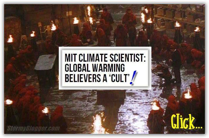
An MIT professor of meteorology is dismissing global-warming alarmists as a discredited cult whose members are becoming more hysterical as emerging evidence continues to contradict their beliefs.
During an appearance on this writers radio show Monday, MIT Professor emeritus Richard Lindzen discussed the religious nature of the movement.
As with any cult, once the mythology of the cult begins falling apart, instead of saying, oh, we were wrong, they get more and more fanatical. I think thats whats happening here. Think about it, he said. Youve led an unpleasant life, you havent led a very virtuous life, but now youre told, you get absolution if you watch your carbon footprint. Its salvation!
Lindzen, 74, has issued calm dismissals of warmist apocalypse, reducing his critics to sputtering rage.
Last week, government agencies including NASA announced that 2014 was the hottest year in recorded history, as The New York Times put it in an early edition. Last year has since been demoted by the Times to the hottest since record-keeping began in 1880.
But that may not be true. Now the same agencies have acknowledged that theres only a 38 percent chance that 2014 was the hottest year on record. And even if it was, it was only by two-100ths of a degree."
MIT Climate Scientist: Global Warming Believers a 'Cult'
2-100ths of a degree warmer? Are these people insane or what?
-
07-03-2015, 10:26 AM #2216I am in Jail
- Join Date
- Feb 2015
- Last Online
- 13-01-2016 @ 11:14 PM
- Posts
- 3,962
Well the global warmist terrorists have Charles Manson on side so it must be true.
-
07-03-2015, 11:01 AM #2217Heading down to Dino's

- Join Date
- Jun 2009
- Last Online
- @
- Posts
- 31,886
^ Earls new multi nic I see.
-
07-03-2015, 09:23 PM #2218Member

- Join Date
- Nov 2006
- Last Online
- @
- Posts
- 715
Originally Posted by Boon Mee
Richard Lindzen | DeSmogBlogProfessor Lindzen's academic interests lie within the topics of “climate, planetary waves, monsoon meteorology, planetary atmospheres, and hydrodynamic instability.”
Lindzen has published work with the conservative think-tank, the Cato Institute, a think tank that has received $125,000 from ExxonMobil since 1998. In his 1995 article, “The Heat Is On,” Ross Gelbspan notes that Lindzen charged oil and coal organizations $2,500 per day for his consulting services.
https://www.skepticalscience.com/ske...rd_Lindzen.htm
-
07-03-2015, 09:25 PM #2219I am in Jail
- Join Date
- Feb 2015
- Last Online
- 13-01-2016 @ 11:14 PM
- Posts
- 3,962
Charles Manson is Earl?
Originally Posted by bsnub
-
08-03-2015, 09:20 AM #2220Heading down to Dino's
- Join Date
- Jun 2009
- Last Online
- @
- Posts
- 31,886
That really sums it up. Boontard posts and reposts the same garbage over and over again, Koman constantly posts about how cold it is and Blue posts...well he thinks homosexuality is a disease so that sums up his intellect. Originally Posted by Umbuku
They are science deniers and have nothing to add expect spam and nonsense. Par the course.
-
08-03-2015, 10:40 AM #2221Thailand Expat
- Join Date
- Aug 2010
- Last Online
- 09-05-2023 @ 11:36 AM
- Location
- Issan
- Posts
- 4,287
That really is shocking news. He worked with an outfit that gets funding from Exxon.......but then look who else gets funding from Exxon. Smithonian Instutute. NOAA, NASA, Harvard, MIT, Stanford etc etc......not to mention both Republican and Democratic parties. Originally Posted by bsnub
Big Oil companies as well as most other larger companies make donations to all kinds of institutions and they hedge their bets with the political parties. It's good PR and also a tax write off. It's important to demonstrate good corporate citizenship you know....
Now, strangely enough it seems only those who support the climate cult are free from any blemish for being funded by these corporations....directly or indirectly. Anybody opposed is immediately tarnished, as we have seen.
Maybe a bit of that old double standard being applied again?....
Then there is the simple matter of responding to the attacks of the anti-corporation outfits. All kinds of groups lobby against corporations at all kinds of levels. Is it surprising that the corporations then hire experts to counter the claims of these groups...which are often hysterical nonsense.
It would seem more appropriate to be looking at the actual findings and arguments put forward by these people instead of flapping about who funds the research....but that might smack of fairness and impartiality....and we can't have too much of that.
-
08-03-2015, 10:51 AM #2222Heading down to Dino's
- Join Date
- Jun 2009
- Last Online
- @
- Posts
- 31,886
Lindzen Cites Debunked Science to Defend Denier-for-Hire Soon in Wall Street Journal
Richard Lindzen, an MIT professor and longtime climate contrarian, turned to the Wall Street Journal to rehash a series of oft-disproved claims that deny the growing and now unequivocal evidence of climate change, all in defense of a fellow "skeptic" whose ties to fossil fuels have called into question the impartiality of his science.
Lindzen's arguments are a greatest-hits of climate denial, repeatedly and effectively disproved for years. He uses these easily dismissed arguments to defend what's left of the academic integrity of Wei-Hock "Willie" Soon against questions raised by members of Congress, who heard testimony from Soon without disclosure that he was being paid by fossil-fuel interests.
Lindzen's writing contained multiple errors or omissions. He:- Ignored the accuracy of climate models over the long term
- Confused the impact of the sun on observed warming, long studied and long ago disregarded
- Dismissed multiple lines of evidence by claiming clouds would offset warming
- Glossed over the egregious breach of ethics in Soon's lack of disclosure of over $1 million in funding from fossil fuel interests
- Mischaracterized as threatening an attempt to identify improper industry influence on studies and Congressional testimony
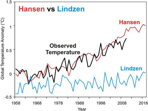
Lindzen makes the tired and debunked claim that predictions of warming haven't been accurate. This is absurd on its face, as 2014 was the hottest year on record, with an unprecedented spike in ocean temperatures. Peer-reviewed studies have shown that model criticisms are totally "unfounded" and that models incorporating the newest information (mainly ocean heat content) are very accurate. Interestingly, comparisons have been made between Lindzen's 1989 predictions and those made in 1988 by James Hansen, former director of NASA's Goddard Institute for Space Studies. The results are clear that mainstream scientists have gotten it right while Lindzen underestimated warming.
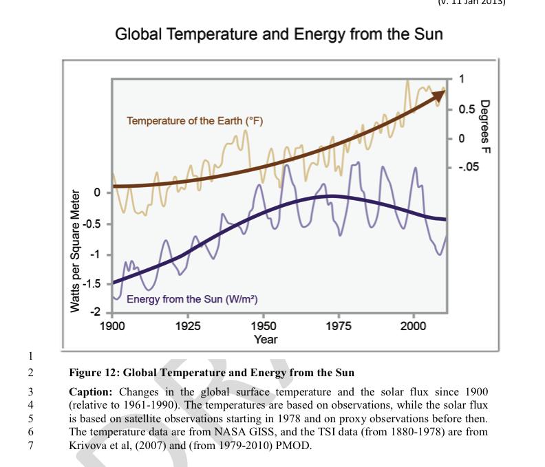
Solar output has decreased as temperatures rise
Lindzen vaguely refers to studies on the role of the sun in driving climate, which is exactly the subject that fossil fuel interests paid Soon to pursue. This is another absurdity, because the amount of energy the sun has sent our way in recent years has actually decreased as temperatures have increased.
More clouds won't offset warming
Lindzen also refers (without citation) to his hypothesis that clouds will cancel out warming. What he doesn't note is that this "Iris hypothesis" has been debunked numerous times, and while cloud behavior is an ongoing area of study when it comes to climate models, clouds may actually increase warming, not offset it as he claims.
$1.2 million is no "small measure" of funding
Soon took over a million dollars from fossil fuel interests in exchange for studies which cast doubt on the CO2-climate change connection in both academic papers and congressional testimony. Soon's contracts went so far as to give funders early access to papers and an explicit agreement to keep the funding relationship secret. Soon told his funders that these activities were "deliverables" yet he failed to disclose this critical fact in the papers. This is as serious as it comes in terms of breaching academic ethics, and has also triggered an internal investigation at Soon's employer.
Congress should know who's sponsoring testimony
Lindzen attempts to redirect attention away from the clear wrongdoing of Soon to the actions of Arizona Rep. Raul Grijalva, who sent letters to seven universities inquiring as to the funding of other witnesses used by the GOP to argue against climate action. As Grijalva states in his letters, this information is vital to disclose because Congress "cannot perform our duties if research or testimony provided to us is influenced by undisclosed financial relationships."
This is not an isolated incident, so Rep. Grijalva has reason to be concerned. As outlined in multiple books (and now a documentary film) the tobacco industry pioneered a method for disputing scientific reality for the purpose of preventing regulation, and the fossil fuel industry has been following this playbook since the 1990s. This strategy involves paying scientists to produce studies contrary to the consensus, testify to Congress disputing the established body of science, and otherwise introduce doubt into the public consciousness where none exists in the scientific literature. This is exactly the behavior of which Soon is guilty, so Rep. Grijalva was right to be concerned about a more widespread coordination of pseudoscientific lobbying against regulations.
Lindzen also writes that he finds it strange that others sent letters to think tanks that promote climate denial, as though he's unaware of the bombshell 2013 study that shed light on the $120 million given to anti-climate groups between 2002 and 2010.
Finally, Lindzen ends with one of the newest fossil fuel talking points, which claims that reducing emissions will somehow hurt the poor. This too is clearly contradicted by the fact that the poorest are least capable of adapting to a changing climate, and those who are actually bringing power to the impoverished are doing so with renewables, not fossil fuels. For example, India's Prime Minister has a goal to bring electricity to all of India using renewables, not fossil fuels.
Link
-
08-03-2015, 11:12 AM #2223RIP

- Join Date
- Jan 2012
- Last Online
- @
- Posts
- 18,083
Snubb being daft as usual. Big Oil is heavily invested in the carbon credit trading scam; if that get pushed on the world, they will make a killing. All this Oil v Bankers talk backing up the carbon credit derivatives scam that they ALL want to create is a load of hog wash.
Who pays for climate change (man made narrative) studies? Government and "founcdations". Who owns or funds governments and foundations? Big business, elites, bankers, big oil. Is there any real difference between Big Oil and Banking Elite? No. They are one in the same. Snubb knows nothing about the real world if he believes that the Koch industries are not in partnerships with Goldman Sachs etc (they even have a business which is a joint venture ffs). All the money Big industry uses for their projects does not come out of their bank accounts, it is created by the banks and lent to them. I have a mate who was CEO of a Chinese oil firm and he showed me on his desk a bundle of papers saying it was basically a Billion Dollar credit note from Bank of America. As I said before, to take big oil from banking is like taking a specific cup of water molecules from a full bath tub.
This is about the trillion dollar plus derivatives scam they all want to have and profit from as well as killing industry in the west to remove the last shreds of the middle class. No other reason for them letting India and China out of their plans other wise.
Its a scam. Climate change happens, and taxing carbon will only create more trouble.
-
08-03-2015, 02:56 PM #2224Thailand Expat
- Join Date
- May 2006
- Last Online
- 13-09-2019 @ 04:18 PM
- Location
- Samui
- Posts
- 44,704
Of course it is. Their whole argument hinges on 2-100ths of a degree warmer. Originally Posted by pseudolus
Fools...
-
08-03-2015, 04:13 PM #2225Thailand Expat
- Join Date
- Aug 2010
- Last Online
- 09-05-2023 @ 11:36 AM
- Location
- Issan
- Posts
- 4,287
So....when bank X provides a credit note to the mom and pop gift shop in some small town in S. Dakota, this is evidence of a joint venture and scam between mom and pop and bank X? Originally Posted by pseudolus
It is the business of banks to provide credit. WTF do you think they do, just take your cash deposits and stick them in their vault?
Oil companies and mom and pop shops both need credit lines to operate effectively....it's just a matter of different limits. Farmers, fishermen, shoe salesmen and even hookers borrow from banks of various kinds as a matter of course.....why would Oil companies be left out?
Is everything in your life really that sinister?....
Actually the answer should be YES. Big Oil as well as small oil and all the various other oils are in the business of finding, extracting and distributing oil; strangely enough. Bet those nasty mining companies and manufacturers of baby foods are all hooked up with the banks too.... Originally Posted by pseudolus
Banks on the other hand won't touch any of this stuff.. They just provide the funding so that the job gets done and of course make a few percent on the payback. The average bank executive probably does not know enough about oil to change the stuff in his car engine.....so really the only thing they have in common is a financial arrangement.
Would this be another Max Keiser quote....or a David Icke theory perhaps?. reptilian blood lines and that sort of thing?.....


 Reply With Quote
Thread Information
Users Browsing this Thread
There are currently 8 users browsing this thread. (0 members and 8 guests)
