
Copernicus April 2023 tied with 2018 to be the 4th warmest April recorded.
Copernicus
___________
This year is shaping up to be one of top four warmest years on record and has a modest chance of being the warmest on record.
Exceptionally warm conditions are being driven by the end of a persistent triple-dip La Niña and a rapid transition into warmer El Niño conditions.
Taking the first three months of the year, global surface temperatures so far are tied as the fourth warmest on record, after 2016, 2020 and 2017.
March 2023 was the second warmest since records began in the mid-1800s, with record warm temperatures in parts of central Asia, coastal China, and Japan, as well as South America.
Based on the year-to-date and the current El Niño forecast, Carbon Brief estimates that 2023 is very likely to end up between the warmest year on record and the sixth warmest, with a best estimate of fourth warmest. So early in the year, it is difficult to precisely predict where annual temperatures will end up.
Arctic sea ice extent is currently on the low end of its historical range, while Antarctic sea ice set new all-time low records in the first two months of 2023, with an all-time low summer minimum for the Southern Hemisphere in February 2023.
El Niño and La Niña events collectively referred to as the El Niño Southern Oscillation, or ENSO are the main driver of year-to-year variation in global surface temperature on top of the long-term warming trend. ENSO events are characterised by fluctuations in temperature between the ocean and atmosphere in the tropical Pacific, which help to make some years warmer and some cooler.
Nearly all forecasts for El Niño/La Niña suggest that El Niño conditions will develop by early summer in 2023, with a number of models projecting strong El Niño conditions (if not quite as strong as the super El Niño events experienced in 1998 and 2016).
Predicting global temperature in 2023
The first three months of 2023 can give some sense of what to expect for the entire year.
By looking at the relationship between the first three months and the annual temperatures for every year since 1970 as well as ENSO conditions for the first three months of the year and the projected development of El Nino conditions for the remaining nine months Carbon Brief has created a projection of what the final global average temperature for 2023 will likely turn out to be.
_________
El Niño is likely to take over soon and odds are it will be sticking around for a long time, national forecasters said in an update Thursday.
While the Northern Hemisphere is still under ENSO-neutral conditions meaning we are neither in an El Niño nor La Niña that could change at any time. The National Oceanic and Atmospheric Administrations Climate Prediction Center said there is about an 80% chance the transition to El Niño takes place between May and July.
Once it takes hold, El Niño is likely to strengthen into the fall and winter, when it normally peaks. The odds of it lasting until February of 2024 are upwards of 90%, the Climate Prediction Center said.
An El Niño winter would be a switch from what what weve seen the last three years, with back to back to back La Niña seasons.
El Niño typically brings cold, wet winter to the Southern U.S. A strong El Niño in particular is associated with lots of rain for the Southwest and California though California already saw a cold, wet winter this year even without El Niño in control.
On the other hand, El Niño usually means a warm, dry winter for the Pacific Northwest, Ohio Valley, northern Rockies and parts of the Midwest. Hawaii also often sees below-average rain during an El Niño fall, winter and spring season.
While El Niño can strengthen hurricane season in the central and eastern Pacific, it tends to contribute to weaker hurricanes forming in the Atlantic basin.
Even a strong El Niño isnt a guarantee those exact scenarios will play out, NOAA warns.
_________
Little extra - Extreme weather
- Record early season heat wave envelopes Pacific Northwest
Nearly 11 million people in the Pacific Northwest were under heat advisories as forecasters warned cities including Seattle and Portland could see more temperature records set Monday from the intense heat wave.
The big picture: The early season heat wave that began Friday has seen temperature records broken from Washington and Oregon to Alberta, where Canadian firefighters have been tackling dozens of wildfires for days, from British Columbia and up to northern Canada.
Meanwhile, beyond the Pacific Northwest, Yosemite National Park announced three campgrounds would temporarily close Monday due to forecast flooding from the melting of the Sierra Nevada's historic snowpack.
- "The combination of extended hot weather and abundant snow means the Merced River may remain above flood stage for some time," the Yosemite National Park Service tweeted.
Threat level: "Above-normal temperatures are forecast to persist along the West Coast ... while extending across the Intermountain West and into the Rockies early this week," the National Weather Service warned Monday.
- "For many locations, daytime temperatures will reach 10-20 degrees above normal on both Monday and Tuesday.
- "While a weak area of low pressure in the upper levels of the atmosphere may provide some relief and an increasing chance for showers and thunderstorms, high temperatures may once again exceed their daily records for parts of the Pacific Northwest, including the Seattle and Portland metro regions, on Monday."
State of play: The National Weather Service reported temperature records in several cities in Washington and Oregon had either been set or tied over the weekend, according to preliminary data.
- The Seattle region saw daily temperature records set or tied in the same four cities for two consecutive days. These included Quillayute which reached 90°F on Saturday, eclipsing the previous record for May 13 set in 1975 by 10 degrees. On Sunday, the data indicates that it tied its monthly record when it hit 92°F, per the NWS.
- Portland recorded its hottest ever daily temperature for May 13 of 93°F on Saturday and set a record temperature for May 14 of 92°F Sunday, according to the preliminary data.
Of note: Preliminary data indicates the tiny community of Arviat, Nunavut, on the western shore of Hudson Bay in northeastern Canada, saw its monthly heat record smashed on Saturday by nearly 7°C (44.6°F), meteorologist Scott Duncan tweeted.
Context: Numerous studies show climate change is leading to more intense heat waves that are more frequent and longer lasting.
https://www.axios.com/2023/05/15/pac...canada-records

Results 6,676 to 6,700 of 6806
Thread: Any doubts about Climate Change?
-
15-05-2023, 06:24 PM #6676Guest Member


- Join Date
- Sep 2008
- Last Online
- @
- Location
- left of center
- Posts
- 20,779
Keep your friends close and your enemies closer.
-
22-05-2023, 01:26 PM #6677Guest Member
- Join Date
- Sep 2008
- Last Online
- @
- Location
- left of center
- Posts
- 20,779
NOAA – April 2023 was the 4th warmest April recorded.

NOAA
__________
- Near certainty that one of next 5 years will be warmest on record, report says
Global average temperature anomalies

There is a 66% probability that global average surface temperatures will exceed the Paris Agreement's 1.5°C target during one of the next five years, the World Meteorological Organization warned Wednesday.
Why it matters: This projection, coming ahead of COP28 in Dubai, could be a wake-up call to world leaders about the fast pace of climate change.
Driving the news: The new report, which is based on computer modeling and climate forecasters' input from the U.K. Met Office and other agencies, also concludes it is a near certainty that one of the next five years will be the warmest on record.
- In addition, the WMO notes the five year period of 2023 through 2027 is almost certain to be the warmest such span since instrument records began in the mid-19th century.
- The WMO cites the likely occurrence of El Niño as one reason for the high odds, because it would boost already elevated global average surface temperatures.
Zoom in: El Niño, while naturally occurring, can amplify human-caused climate change by adding more heat to the oceans and atmosphere.
- For example, the current record-holder for the warmest year is 2016, which coincided with a strong El Niño.
- The chance of exceeding 1.5°C, albeit briefly, have quickly risen in recent years, from near zero in 2015 to 10% between 2017-2021, the WMO stated.
- The probability given last year for the period through 2026 was 50%.
Between the lines: The Paris target refers to a long-term average, not exceeding 1.5°C in an individual year.
- But the WMO director foresees the world will soon see global average temperatures eclipsing 1.5-degrees on a more routine basis.
What they're saying: "The WMO is sounding the alarm that we will breach the 1.5°C level on a temporary basis with increasing frequency," WMO secretary-general Petteri Taalas said in a statement.
Meanwhile, a new climate attribution study investigating the April heat wave across Asia found that human-caused climate change made the weather event at least 30 times more likely in Bangladesh, India, Laos and Thailand.
Climate change also made the heat wave more severe, increasing temperatures by at least 2°C (3.6°F), compared with a world without added greenhouse gases.
Zoom in: In Laos and Thailand, where the heat was especially fierce, researchers found the extreme heat would have been nearly impossible without the influence of climate change.
Yes, but: The new paper uses peer-reviewed methods to examine an event in near-real time, but it has not yet been reviewed on its own.
___________
"The Supreme Court's decision brings the people of Delaware and Hoboken one step closer to putting these polluters on trial and making them pay for their climate deception."
On the heels of similar decisions last month, the U.S. Supreme Court on Monday delivered "another win for climate accountability," rejecting fossil fuel corporations' attempt to quash lawsuits filed by the city of Hoboken, New Jersey, and the state of Delaware.
Both filed in September 2020, the suits from Hoboken and Delaware—like those filed by dozens of other municipalities and states—take aim at companies including BP, Chevron, ConocoPhillips, ExxonMobil, and Shell for fueling the climate emergency. The fossil fuel industry has repeatedly tried to evade accountability by shifting such cases from state to federal court.
"We appreciate and agree with the court's order denying the fossil fuel companies' petition, which aligns with dozens of decisions in federal courts here in Delaware and across the country," said Democratic Delaware Attorney General Kathy Jennings in response to Monday's decision.
The Supreme Court's decision means that both of these cases will now move forward in state court.
Jennings on Monday cited an opinion piece she wrote for Delaware Online with Shawn Garvin, secretary of the Delaware Department of Natural Resources and Environmental Control, back when they launched the legal effort in 2020:
As we stated at the time of filing this case almost three years ago: "It didn't have to be this way. The fossil fuel industry knew for decades that their products would lead to climate change with potentially 'severe' and even 'catastrophic' consequences—their words, not ours. But they didn't clean up their practices or warn anyone to minimize the peril they were creating. Instead, they spent decades deliberately and systematically deceiving the nation about what they knew would happen if they carried on with business as usual."
Building on revelations from the past decade that have bolstered climate liability lawsuits, peer-reviewed research published in January shows that ExxonMobil accurately predicted global heating decades ago, while documents released in early April make clear that Shell knew about the impact of fossil fuels even earlier than previously thought.
"Imagine how far along we might be in the transition to a low-carbon economy today if not for their deception," Jennings said. "That's why we filed our lawsuit, and today's order moves Delawareans one step closer to the justice and economic relief that we deserve."
For Hoboken and Delaware, the high court denied fossil fuel companies' challenge to decision last year from a panel at the U.S. Court of Appeals for the 3rd Circuit, which wrote in part that "our federal system trusts state courts to hear most cases—even big, important ones that raise federal defenses. Plaintiffs choose which claims to file, in which court, and under which law. Defendants may prefer federal court, but they may not remove their cases to federal court unless federal laws let them. Here, they do not."
Center for Climate Integrity president Richard Wiles noted Monday that "Big Oil companies keep fighting to avoid trials in state courts, where they will be forced to defend their record of climate lies and destruction in front of juries, but federal courts at every level keep rejecting their efforts."
"The Supreme Court's decision brings the people of Delaware and Hoboken one step closer to putting these polluters on trial and making them pay for their climate deception," Wiles added. "Fossil fuel companies must be held accountable for the damages they knowingly caused."
After the high court's April decisions—which involved cases brought by the state of Rhode Island as well as municipalities across California, Colorado, Hawaii, and Maryland—Jamie Henn of Fossil Free Media said, "This should open the floodgates for more lawsuits that could make polluters pay!"
There were no noted dissensions on Monday. However, like last month, Justice Samuel Alito, who owns stock in some fossil fuel companies, did not participate in the decision about these two cases—but Justice Amy Coney Barrett, whose father spent nearly three decades as an attorney for Shell, did.Last edited by S Landreth; 22-05-2023 at 01:46 PM.
-
22-05-2023, 05:15 PM #6678In Uranus


- Join Date
- Jun 2009
- Last Online
- @
- Posts
- 30,560
Another hot and dry summer for the PNW and as has been par the course for the last several years Western Canada is on fire already, and we are unfortunately downwind.
-
30-05-2023, 05:08 PM #6679Guest Member
- Join Date
- Sep 2008
- Last Online
- @
- Location
- left of center
- Posts
- 20,779
NASA - April 2023 was the 4th warmest April recorded

NASA
_________
- Reported deaths and disasters, by United Nations country classification

An updated, authoritative United Nations disasters analysis out this morning shows there were nearly 12,000 disasters attributable to extreme weather and climate-related events during the 1970-2021 period, Andrew writes.
The big picture: Such disasters are becoming more expensive, with a total bill of $4.3 trillion and rising. At the same time, however, they are getting less deadly.
- The pattern of disasters spotlights global inequality, with 90% of the slightly more than 2 million deaths during this period taking place in developing countries.
- However, the vast majority of economic losses stemmed from industrialized countries.
- Climate change is influencing the frequency and severity of certain extreme weather and climate events, particularly heat waves, extreme precipitation events and tropical cyclones.
- However, climate change is not thought to be the biggest driver of disaster loss trends, other research has found.
Zoom in: The update to the World Meteorological Organizations (WMO) Atlas of Mortality and Economic Losses from Weather, Climate and Water-related hazards, extends the disaster metrics to 51 years.
- The U.S. alone took a US$1.7 trillion hit during the 1970-2021 period, accounting for about 40% of economic losses during the past 51 years.
- Extreme temperatures were the leading cause of reported deaths and floods drove the biggest costs, the WMO found.
- With certain types of extreme weather and climate events becoming more common and severe, the future of disaster losses will hinge on societal exposure to such hazards.
What we're watching: How the U.N.'s push to deploy early warning systems to every country by 2027 progresses.
__________
- Nearly 2 billion at risk from "unprecedented" climate conditions
Absent new, more ambitious climate policies, the world is headed for a magnitude of climate change that would put about 2 billion people at risk of extreme heat by the end of the century, a new study finds.
Why it matters: Limiting global warming to the Paris Agreement's target of 1.5°C (2.7°F) above preindustrial levels would yield a five-fold reduction in the population exposed to unprecedented heat by the end of this century.
- The nearly 1.2°C (2.16°F) increase in global average surface temperatures to date has already knocked more than 600 million people out of the "human climate niche" in which society has historically thrived.
- The researchers of the study, published Monday in Nature Sustainability, define that niche by looking at how human population density varies with temperature and precipitation.
The intrigue: They find two peaks in population density, one associated with a mean annual temperature of about 13°C (55.4°F), and the other tied to more tropical climates, at 27°C (80.6°F).
- Outside of these temperatures, conditions tend to be either too wet or dry, or too hot or cold, for high concentrations of people to thrive, the study states.
What they're saying: "The human climate niche shows how human population density varies with average temperature and average precipitation," said Tim Lenton, study lead author and director of the University of Exeter's Global Systems Institute.
- "It thus shows the temperature and rainfall levels we flourish most at, and how population density drops moving away from those peaks," he told Axios in an email.
Between the lines: The researchers sought to shed light on the current and projected human toll of climate change.
- Unprecedented heat exposure is defined as having a mean annual air temperature of 84.2°F (29°C), which the scientists found correlated with more frequent spikes to greater than 40°C (104°F), and potentially lethal wet bulb temperatures of greater than 28°C (82.4°F).
- Wet bulb temperatures incorporate humidity; once they climb to about 35°C (95°F), they can cause potentially fatal heat-related illness by impeding the human body's ability to cool itself through sweat.
Of note: The study found that if countries only meet existing emissions reductions based on current policies, and warming were to reach 2.7°C by 2100 (4.8°F), the top 5 countries most vulnerable to unprecedented heat (based on the number of people exposed) would be India, Nigeria, Indonesia, the Philippines and Pakistan.
- In this scenario, up to a third of humanity would be exposed to such extreme heat and be well outside the human climate niche, the study found.
Yes, but: The heat would not hold off until the end of the century, but ratchet up noticeably over time.
- The study concludes that for every 0.1°C (0.18°F) increase in global average surface temperatures, another 140 million people will be exposed to dangerous heat.
The big picture: Extreme heat this week illustrates the challenges these countries are already facing face, with temperatures in Delhi, India reaching 46.5°C (115.7°F) on Monday.
- Heat waves already have toppled monthly and all-time records across swaths of Asia during April into May, which scientists have tied in part to human-caused climate change.
- Other studies have pointed to the dangers of temperatures hitting intolerable limits, which challenge humans' physiological abilities to withstand such conditions, with increasing frequency.
The bottom line: Unless nations take more stringent actions to rein in global greenhouse gas emissions, extreme heat will only get more dangerous and prevalent.
https://www.axios.com/2023/05/23/cli...dangerous-heat
_________
- Zeke Hausfather - In a recent piece in the journal Nature, @ClimateFran and I assessed the literature on current policy, 2030 commitments, and net-zero pledges compared to the range of outcomes in the recent IPCC report: https://www.nature.com/articles/d41586-022-00874-1

_________
- Emissions are no longer following the worst case scenario
If you step back in time to 2014, global CO2 emission told a pretty frightening story. Emissions had rapidly increased at a rate of 3% per year in the 2000s, and there was not much sign yet of a slowdown in the early 2010s. Global emissions appeared to be following the worst case (RCP8.5) scenario.
But over the last decade things have started to change.
Global CO2 emissions (both fossil and land use) have been relatively flat during the 13 years after 2010, and are now closer to the middle-of-the-road RCP4.5 scenario than the high-end RCP8.5 one. This is even more clear if we look at fossil CO2, which is the most important factor in long-term growth (as its responsible for 90%+ of future emissions in high-end scenarios).
This is due to the rapidly accelerating energy transition driven by falling costs of clean energy technologies, that has led to a stagnation of global coal use. The world spent $1.1 trillion dollars on clean energy technologies in 2022, up from around $780 billion in 2021 and $600 billion in 2020, a trend that shows no sign of slowing down.
Even more importantly, there is a growing consensus in the literature that global emissions are likely to remain flat even in the absence of strong climate policies enacted by countries. The figure below is from the IPCC 6th Assessment Report Synthesis, and shows the range of assessed current policy projections for global CO2 emissions in red (along with a somewhat arbitrary selected marker scenario in with a solid red line).

Figure Figure SPM.5 from the AR6 Synthesis Report (2023). The red area shows the range of current policy scenarios in the literature, with the darker part showing the more likely scenarios. Green and blue areas show below-2C and 1.5C emissions scenarios, respectively.
https://theclimatebrink.substack.com...nger-following
-
04-06-2023, 01:47 PM #6680Guest Member
- Join Date
- Sep 2008
- Last Online
- @
- Location
- left of center
- Posts
- 20,779
JMA April 2023 was the 4th warmest April recorded

Five Warmest Years (Anomalies)
1st. 2016 (+0.46°C), 2nd. 2020 (+0.36°C), 3rd. 2019 (+0.34°C), 4th. 2023 (+0.32°C), 5th. 2017 (+0.26°C)
JMA
________
Changes to circulation in parts of the Southern Ocean are taking place faster than expected, with potentially profound implications for the global climate and marine life, a new study finds.
Why it matters: The Southern Ocean is home to the engine that powers the world's deep ocean currents, and regulates the climate. It governs the exchange of heat, carbon, oxygen and nutrients between ocean layers.
The big picture: There are only two main regions on the planet where cold, salty and dense water forms and sinks to the bottom of the sea, before slowly moving outward thousands of miles. This water eventually rises again to the surface, often years later.
- One such spot is in the North Atlantic, near Greenland, and the other is in the Southern Ocean, in pockets surrounding Antarctica.
- Both are exhibiting signs of stress as climate change melts land-based ice sheets, pouring lightweight freshwater into the upper layers of the ocean.
- This disrupts ocean currents that are driven by the vertical exchange of waters.
- A key part of such currents is Antarctic "bottom water" that forms off the frigid though rapidly warming continent's coasts.
Of note: Antarctic bottom water makes up nearly half the volume of the global ocean, and helps power what the late geoscientist Wallace "Wally" Broecker described as the Great Ocean Conveyor Belt.
Zoom in: The new study, published May 25 in the journal Nature Climate Change, finds evidence that at least one area of the Southern Ocean that drives this cycle is changing faster than previously anticipated.
- The results raise questions about the long-term vitality of this delicately interconnected series of ocean currents in the face of melting ice sheets.
- The research uses observational data to show that the overturning circulation has slowed by nearly 30% in the Australian Antarctic Basin between 1994 and 2017; deep ocean oxygen levels are declining there too.
- This area lies downstream of the Amundsen Sea, an area of large ice mass loss from increasing air and sea temperatures.
Between the lines: Lead author Kathryn Gunn of the Australian science agency CSIRO and Southampton University told Axios that observations don't yet show the same rapid trends occurring in other spots around Antarctica.
- "This basin gives an indication for what could happen in other basins," Gunn said via email. "This is further motivation to reduce greenhouse gas emissions as fast as possible."
- She noted that widely used climate projection models show far slower consequences for deep ocean circulation than what is actually occurring in the Southern Ocean.
What they're saying: The study's results, said co-author Matthew England of the University of New South Wales, are a concerning sign of an amplifying climate feedback, which may in turn speed up climate-induced ice melt.
- "Dense shelf water overturning keeps the Antarctic continental shelves cold. If we lose that, wed expect those shelves to warm," he told Axios in an email.
- "Thats bad news as it would drive further ice melt."
Flashback: A previous study involving some of the same authors and published in Nature in late March, combined observational data from the 1990s through the 2000s with computer modeling experiments.
- It predicted just over a 40% net slowdown in the global overturning circulation by 2050 due to increased meltwater, with impacts that "could last for centuries."
- Gunn said the new research is consistent with that modeling.
- In concert with the Antarctic findings, recent research has also shown that the Atlantic Meridional Overturning Circulation is slowing as a result of freshwater floes from the Greenland Ice Sheet.
The bottom line: The new study is a warning sign of potential future changes to a crucial ocean cycle as ice melt continues, barring rapid and steep cuts to greenhouse gas emissions.
_________
- Near record warm oceans, developing El Niño escalates hurricane risks
Threats from the still-emerging Atlantic hurricane season are converging as oceanic and atmospheric trends underscore how climate change is creating unprecedented storm conditions.
The big picture: The tropical Atlantic is especially toasty, particularly temperatures in a crucial swath of the sea known as the "Main Development Region," where many tropical storms and hurricanes form and intensify.
- Ocean temperatures in this area are closely watched at the start of the season and used as a determining factor in predicting storm activity.
- In many seasons, freshening trade winds tend to cool those waters down. This year, thats not expected to happen.
- Climate change is a major factor driving ocean temperatures higher.
Why it matters: Warmer waters are a concern for officials and meteorologists responsible for tracking landfalling storms along the East and Gulf Coasts, since it would suggest a more active season ahead.
- As a reminder to expect the unexpected this season, the first tropical cyclone of the season known simply as Tropical Depression Two formed Thursday in the northeastern Gulf of Mexico.
- It may briefly become Tropical Storm Arlene on Friday, but is no threat to land.
Meanwhile... A likely El Niño event in the tropical Pacific Ocean continues to form, with unusually warm sea surface temperatures at play there, too.
- There are signs the atmosphere is beginning to respond to the ocean conditions in a key region that helps climate scientists diagnose El Niño events, known as "Niño 3.4."
- The atmosphere's feedback is a prerequisite for the climate cycle's formation and staying power.
- Some reliable computer models project a moderate-to-strong El Niño may soon be underway, possibly by the height of the hurricane season in the late summer and early fall.
- Typically, these events make for less active Atlantic hurricane seasons based on how they affect weather patterns.
Yes, but: With climate change elevating ocean temperatures throughout the Atlantic, beyond the tropics, and large stretches of the expansive Pacific, there is nothing typical about this setup.
- In fact, ocean temperatures have been at or close to record levels globally this spring.
This season is in nearly uncharted territory, with no consistent past lessons for forecasters to draw from in order to get a sense of where things are headed.
- Will it be another record-breaker, with storms extending into the Greek alphabet, as in 2020? Most likely no, federal and private sector forecasts indicate but Atlantic Ocean conditions look eerily similar.
- Still, it's also unlikely to be below average, like previous El Niño years.
Threat level: An additional risk that warm water brings is the increased likelihood of rapidly intensifying tropical storms and hurricanes. That has been happening with greater frequency and magnitude as the climate warms.
Context: Emphasizing this point, a hurricane forecast group at Colorado State upped its Atlantic outlook on Thursday to a total of 15 named storms this season, citing ocean temperatures as a key reason.
- This is an increase from 13 named storms in its previous forecast.
- Of that number, it predicts 7 will become hurricanes with 3 major hurricanes of Category 3 or greater, which are also increases.
- Forecasters cited sea surface temperatures as the main reason for the change.
What they're saying: Michael Lowry, a hurricane specialist at WPLG Local 10 in Miami, said current historically high sea surface temperatures, along with the moderate-to-strong El Niño and warmth in the tropical Atlantic, have no real precedent.
- "We don't have many great analogs in part because global sea surface temperatures have never been so warm," he said.
https://www.axios.com/2023/06/02/atl...oceans-climate
_________
Extra
- Insurer cites "growing catastrophe exposure" as it stops new sales in California
State Farm says it's no longer accepting homeowner insurance applications in California due to "historic increases in construction costs outpacing inflation" and "rapidly growing catastrophe exposure" to extreme weather events like wildfires.
Why it matters: Multiple studies show climate change is influencing the frequency and severity of extreme weather events, increasing the risk of wildfires and also the proportion of storms that reach major hurricane status of Category 3 or above.
- With more severe and frequent severe weather events and extreme weather swings, the resilience of homeowners and communities is on the line and how lenders, insurance companies and others incorporate escalating risks is a key issue, per Axios' Andrew Freedman.
Zoom in: State Farm was the top home insurance firm in the state before it ceased operations Saturday, per the Insurance Information Institute. The American International Group announced last year it was pulling policies in the state amid wildfire risk concerns.
- California Insurance Commissioner Ricardo Lara moved to protect homeowners by introducing insurance pricing regulations, including a one-year moratorium preventing homeowner insurance cancellations and non-renewals in some fire-affected counties.
Zoom out: It's not just California. Some insurers pulled out of Louisiana and Florida last year after forecasters warned of "another active Atlantic hurricane season," per Bloomberg.
- Florida is facing an insurance crisis ahead of the official start of the hurricane season on June 1, when property insurance companies in the state to get their reinsurance in place, Axios Miami's Deirdra Funcheon reports. Some companies have gone insolvent and rates have skyrocketed.
By the numbers: There were nearly 12,000 disasters attributable to extreme weather and climate-related events during the 1970-2021 period costing $4.3 trillion and rising, according to updated United Nations analysis out last week.
- In California, Cal Fire reports 7,490 wildfires razed 362,455 acres, killing nine people and destroying or damaging 876 structures.
What they're saying: "We take seriously our responsibility to manage risk. We recognize the Governors administration, legislators, and the California Department of Insurance (CDI) for their wildfire loss mitigation efforts," State Farm said in a statement Friday that emphasized existing customers wouldn't be affected by the decision.
- "We pledge to work constructively with the CDI and policymakers to help build market capacity in California. However, its necessary to take these actions now to improve the companys financial strength."
Meanwhile, CDI spokesperson Michael Soller, the Californian deputy insurance commissioner, said in an emailed statement Sunday night that while insurance companies prioritize their short-term financial goals, the long-term goal of the Department of Insurance is protecting consumers.
- "The factors driving State Farms decision are beyond our control, including climate change, reinsurance costs affecting the entire insurance industry, and global inflation," Soller said.
- "We have been here before after major wildfires. Whats different is the actions that we are taking with the first-ever insurance discount program for wildfire safety and unprecedented wildfire mitigation investments from the Legislature and Governor."
The bottom line: "Home insurance is a key way that people manage risk of climate-related hazards," said Noah Diffenbaugh, a climate scientist and professor at Stanford University to the Washington Post Sunday.
- "And were seeing that these events can be very costly both at the individual level," he added. "And clearly can be very costly for insurance companies."
https://www.axios.com/2023/05/29/sta...rnia-wildfires
-
05-06-2023, 11:14 AM #6681Thailand Expat

- Join Date
- Apr 2006
- Last Online
- Today @ 07:25 AM
- Location
- Not far from Ratchada.
- Posts
- 1,766
I am amazed that there are still people (well, Republicans & Tories) who refer the the 'climate change hoax'. I think that we can all see the climate changing first hand now. It's not just numbers on a graph, it's drought, wildfires and really hot summers right outside our doors.
-
09-06-2023, 07:46 AM #6682Guest Member
- Join Date
- Sep 2008
- Last Online
- @
- Location
- left of center
- Posts
- 20,779
El Niño officially develops amid record weather extremes: NOAA

El Niño, the ocean and atmosphere cycle in the tropical Pacific that can supercharge global extreme weather events, is officially back after about a four-year hiatus, NOAA announced Thursday morning.
Why it matters: El Niño holds large sway over global weather patterns. It is likely to increase global average surface temperatures, leading to an all-time record warm year in 2023 or 2024, surpassing the El Niño year of 2016.
- El Niño will also contribute to heat waves, droughts, floods and other weather extremes, which already are worsening from human-caused climate change.
- It is influencing the North Atlantic hurricane season, making for an especially uncertain outlook.
Zoom in: El Niño events are characterized by unusually warm sea surface temperatures in the equatorial tropical Pacific, particularly across the central and eastern Pacific.
- NOAA's advisory on Thursday morning indicates that both ocean temperatures and atmospheric conditions are sufficient for an El Niño to be declared.
- During an El Niño, the ocean conditions in turn drive atmospheric responses. These include a reversal of the typical trade winds across the ocean basin and shifts, where heavy tropical downpours tend to develop near the equator.
The intrigue: Some climate scientists and meteorologists told Axios they are looking toward the coming months to a year or more with trepidation and curiosity, given that the oceans already are record-warm going into the event, and are now likely to get even warmer.
- The global oceans are very warm right now and Im afraid that this is putting us into territory that we dont have much experience with, Michelle L'Heureux, chief of Climate Prediction Center's El Niño-Southern Oscillation team, said in an interview.
- And on land, scorching heat waves have struck large swaths of Asia this spring, while Canada is amid what is likely to be its worst wildfire season on record.
- Fires burning in Quebec turned the skies in New York City a bright, otherworldly orange on Wednesday.
- Given that El Niño years tend to yield global temperature milestones and are associated with notable extreme weather and climate events, L'Heureux said this event could provide a preview of what our typical climate will look like in a decade or two as warming continues.
- It is a little bit nerve-wracking, she said.
Of note: The natural climate phenomenon now occurs against a backdrop of a rapidly warming planet being worsened by human emissions of fossil fuels. It makes the evolution and impacts more uncertain and potentially more significant, experts told Axios.
- NOAA's Climate Prediction Center forecasts this El Niño has an 84% likelihood of exceeding moderate intensity and a 56% chance of reaching "strong" criteria.
Between the lines: Zeke Hausfather, climate research lead at payments company Stripe, said that El Niño's development means there is about a 30% to 50% chance that 2023 will set a record for the warmest year in instrument records, which date back to 1850.
- However, 2024 is even more likely to do so, provided the El Niño continues to develop and strengthen.
- Kim Cobb, director of the Institute at Brown for Environment and Society who is the first climate scientist to sit on the president's intelligence advisory board, said the next annual temperature record may be considerably higher than 2016's.
- "A new global temperature record is by no means an unusual occurrence of late, but I suspect the magnitude of any new El Niño-related new record may be shocking to many, as it was in 2016," Cobb said in an email.
Yes, but: While it's clear that ocean temperatures and atmospheric conditions now support the El Niño designation, it is not guaranteed to continue developing into a long-lasting event, L'Heureux cautioned.
- In fact, the extraordinarily warm sea surface temperatures present across the tropical Pacific Ocean could complicate its intensification, since typically the waters in the western Pacific are cooler than they are now. That affects weather patterns in the central and eastern Pacific integral to El Niño's progression.
- It also makes me wonder how the event is going to unfold going forward, she said, noting the record-warm oceans have the potential to cause a "black swan" outcome.
What they're saying: Cobb said she is particularly concerned about El Niño's ocean-related effects.
- "Going into this El Niño with record-breaking ocean temperatures in many basins is worrying, from the standpoint of marine ecosystems, given that this El Niño will drive additional ocean warming," Cobb said.
- "Many ecosystems, including many coral reefs, are still reeling from the impacts of the 2016 El
________
La Niña, Neutral and El Niño years are (on average) warming

________
This is more of an awareness thread now. Originally Posted by qwerty

I believe most of the hardcore climate deniers understand human activity is the main cause of the warming we are seeing today.
Theyve just dug themselves a hole and are unwilling to admit the mistake theyve made by not following the science.
But it is still fun to goof on the deniers when they post here.Last edited by S Landreth; 09-06-2023 at 07:51 AM.
-
12-06-2023, 12:42 PM #6683Guest Member
- Join Date
- Sep 2008
- Last Online
- @
- Location
- left of center
- Posts
- 20,779
Copernicus May 2023 was the 3rd warmest May recorded

Extra:
The ERA5 data indicate that sea surface temperatures (from 60°S to 60°N) in May were higher than in any previous May in the data record.

Copernicus
__________
Carbon dioxide levels measured at NOAAs Mauna Loa Atmospheric Baseline Observatory peaked at 424 parts per million in May, continuing a steady climb further into territory not seen for millions of years, scientists from NOAA and Scripps Institution of Oceanography at the University of California San Diego announced today.
Measurements of carbon dioxide (CO2) obtained by NOAAs Global Monitoring Laboratory averaged 424.0 parts per million (ppm) in May, the month when CO2 peaks in the Northern Hemisphere. That is an increase of 3.0 ppm over May 2022, and represents the fourth-largest annual increases in the peak of the Keeling Curve in NOAAs record. Scientists at Scripps, which maintains an independent record, calculated a May monthly average of 423.78 ppm , also a 3.0 ppm increase over their May 2022 average.
Carbon dioxide levels are now more than 50% higher than they were before the onset of the industrial era.

Every year we see carbon dioxide levels in our atmosphere increase as a direct result of human activity, said NOAA Administrator Rick Spinrad, Ph.D. Every year, we see the impacts of climate change in the heat waves, droughts, flooding, wildfires and storms happening all around us. While we will have to adapt to the climate impacts we cannot avoid, we must expend every effort to slash carbon pollution and safeguard this planet and the life that calls it home.
Carbon dioxide pollution is generated by burning fossil fuels for transportation and electrical generation, by cement manufacturing, deforestation, agriculture and many other practices. Like other greenhouse gases, CO2 traps heat radiating from the planets surface that would otherwise escape into space, amplifying extreme weather events, such as heat waves, drought and wildfires, as well as precipitation and flooding.
Rising CO2 levels also pose a threat to the world's ocean, which absorbs both CO2 gas and excess heat from the atmosphere. Impacts include increasing surface and subsurface ocean temperatures and the disruption of marine ecosystems, rising sea levels and ocean acidification, which changes the chemistry of seawater, leading to lower dissolved oxygen, and interferes with the growth of some marine organisms.
__________
It is now too late to save summer Arctic sea ice, research has shown, and scientists say preparations need to be made for the increased extreme weather across the northern hemisphere that is likely to occur as a result.
Analysis shows that even if greenhouse gas emissions are sharply reduced, the Arctic will be ice-free in September in coming decades. The study also shows that if emissions decline slowly or continue to rise, the first ice-free summer could be in the 2030s, a decade earlier than previous projections.
The research shows that 90% of the melting is the result of human-caused global heating, with natural factors accounting for the rest.
Since satellite records began in 1979, summer Arctic ice has shrunk by 13% a decade, in one of the clearest signs of the climate crisis. Arctic sea ice reaches its annual minimum at the end of summer, in September, and in 2021 it was at its second lowest extent on record.
Unfortunately it has become too late to save Arctic summer sea ice, said Prof Dirk Notz, of the University of Hamburg, Germany, who was part of the study team. As scientists, weve been warning about the loss of Arctic summer sea ice for decades. This is now the first major component of the Earth system that we are going to lose because of global warming. People didnt listen to our warnings.
This brings another warning bell, that the kind of projections that weve made for other components of the Earth system will start unfolding in the decades to come.
Other climate scientists said in 2022 that the world was on the brink of multiple disastrous tipping points.
Prof Seung-Ki Min, of Pohang University, South Korea, who led the new study, said: The most important impact for human society will be the increase in weather extremes that we are experiencing now, such as heatwaves, wildfires and floods. We need to reduce CO2 emissions more ambitiously and also prepare to adapt to this faster Arctic warming and its impacts on human society and ecosystems.
Observationally-constrained projections of an ice-free Arctic even under a low emission scenario | Nature Communications
-
21-06-2023, 08:20 AM #6684Guest Member
- Join Date
- Sep 2008
- Last Online
- @
- Location
- left of center
- Posts
- 20,779
NOAA May 2023 was the 3rd warmest May recorded

Spring 2023 (March, April, May) was the 3rd warmest Spring recorded

NOAA
___________
Global temperatures have accelerated to record-setting levels this month, an ominous sign in the climate crisis ahead of a gathering El Niño that could potentially propel 2023 to become the hottest year ever recorded.
Preliminary global average temperatures taken so far in June are nearly 1C (1.8F) above levels previously recorded for the same month, going back to 1979. While the month is not yet complete and may not set a new June record, climate scientists say it follows a pattern of strengthening global heating that could see this year named the hottest ever recorded, topping 2016.
There has been remarkable global warmth so far in June, confirmed Copernicus, the European Unions Earth observation arm, which said that the first few days of the month even breached a 1.5C increase compared with pre-industrial times. This is probably the first time this has happened since industrialization, the agency said.
The long-term warming conditions caused by the burning of fossil fuels will probably receive a further pulse of heat via El Niño, a naturally recurring phenomenon where sections of the Pacific Ocean heat up, typically causing temperatures to spike across the world.

Last week, the National Oceanic and Atmospheric Administration (Noaa) said El Niño conditions are now present and will gradually strengthen into early next year. Michael Mann, a climate scientist at the University of Pennsylvania, said human-caused warming will be exacerbated by an event that typically adds between 0.1C to 0.2C (0.18F to 0.36F) to the overall global temperature.
The global surface temperature anomaly is at or near record levels right now, and 2023 will almost certainly be the warmest year on record, said Mann. That is likely to be true for just about every El Niño year in the future as well, as long we continue to warm the planet with fossil fuel burning and carbon pollution.
While people are feeling the heat on land, an even more remarkable burst of warmth is occurring in the seas, with Noaa confirming a second consecutive month of record high ocean surface temperatures in May. Excess heat in the oceans, which cover 70% of the globes surface, influence overall global temperatures, as well as warp fish populations, bleach coral reefs and drive coastal sea level rise.
The oceans have been warming steadily but we are now seeing record temperatures which is certainly alarming given we are expecting El Niño to strengthen, said Ellen Bartow-Gillies, a climate scientist at Noaa. That will undoubtedly have an impact on the rest of the world.

____________
Because of the lag between the development of an El Niño and its maximum impact on global temperatures, an El Niño that develops during 2023 is likely to have an even larger warming effect on global mean temperature in 2024 than 2023.

Likelihood of final 2023 ranking:
- 1st place (54 %)
- 2nd or 3rd place (26 %)
- 4th place (18 %)
- 5th place (1 %)
- Top 5 overall (> 99 %)
____________
- Climate extremes raise questions, concerns about faster warming
An assortment of climate scientists, meteorologists and others are expressing alarm at recent changes in key climate indicators.
The big picture: Global surface air and ocean temperatures have spiked sharply in recent months, along with record low Antarctic sea ice, extreme heat events around the world, as Canada's heat and wildfire crisis grips North America.
- Along with other developments, the combination of those factors have raised alarms regarding whether climate change is accelerating
Driving the news: In Twitter threads and via other social media platforms, climate experts have been noting the state of affairs with at least some nervousness. Right now, global sea and air temperatures are at record highs for this time of year, and climbing.
- The unusual warmth in the North Atlantic Ocean is particularly eye-catching, and it raises fears of a more active hurricane season than what is typically expected in a year with an El Niño present.
- El Niño tends to reduce the number of Atlantic tropical storms and hurricanes.
- In a viral tweet over the weekend, meteorologist Brian McNoldy of the University of Miami called global air and ocean temperature trends "bonkers," stating: "People who look at this stuff routinely can't believe their eyes. Something very weird is happening."
- The warmer than usual Atlantic waters are already having dangerous impacts, including contributing to Puerto Rico's worst heat wave on record.
Of note: Global extreme heat events have smashed records during the spring and so far during meteorological summer, which commenced on June 1.
- Heat waves in Canada along with dry conditions have helped lead to historic wildfires, some of which caused the worst wildfire-related smoke event on record in the U.S. since at least 2006 last week.
- Record heat has also enveloped large parts of Asia, setting monthly records in China, along with parts of Siberia.
Between the lines: At first glance, it might appear to be a sudden and potentially risky acceleration of climate change. But each of the collective trends observed so far may be explained by a mix of natural and human-made factors that are relatively well-known with a couple of wild cards thrown in, climate scientists told Axios.
- Zeke Hausfather, climate research lead at payments company Stripe, attributed some of the warming to the transition out of a cool La Niña phase of the Pacific to El Niño.
- "In general, I think the level of excitement around recent sea surface temperature records in some quarters is a bit over the top," he told Axios via email.
- "The world is warming rapidly, broadly in-line with climate model projections. It's going to get bad if we don't rapidly reduce emissions, with more extreme heat events, record-setting global and regional temperatures, severe wildfires, and other extreme events where there are clear climate linkages," he said.
Yes, but: "We don't have any evidence that warming is accelerating beyond the range that scientists have previously predicted it would. What we expect is bad enough!" the researcher added.
- Hausfather's view was shared by others, including Michael Mann of the University of Pennsylvania, who identified abnormally low levels of dust blowing from the Sahara Desert across the Atlantic as a factor in how warm parts of the tropical Atlantic are right now.
- Dust transport each year tends to hold down Atlantic Ocean temperatures slightly, and also makes the atmosphere less hospitable to tropical storms and hurricanes.
What they're saying: Daniel Swain, a climate scientist at UCLA, argued during via a Youtube question and answer session Monday that he didn't believe "this current escalation is necessarily an indication that there's any dramatic underestimation of the warming, it's just sort of an exclamation point on the long-term Trend as we stair step up."
- "It's two steps forward and one step back, that's the natural variability, if you will, on top of the [human-caused, long-term] warming trend."
The intrigue: Two relatively poorly understood factors that may be contributing to the ongoing climate extremes include:
- A switch made to marine fuels beginning in 2020 that has led to reduced sulfur dioxide emissions in the tropics, which acted to reflect some incoming solar radiation. However, how influential this factor is is not yet clear.
- There is also the 2022's Hunga Tonga volcanic eruption, which contributed large amounts of water vapor to the stratosphere, warming that atmospheric layer.
The bottom line: Are these trends concerning? Yes. But do they mean climate projections are missing the mark? Not yet, researchers said.Last edited by S Landreth; 21-06-2023 at 08:25 AM.
-
26-06-2023, 07:06 PM #6685Guest Member
- Join Date
- Sep 2008
- Last Online
- @
- Location
- left of center
- Posts
- 20,779
NASA – May 2023 was the 3rd warmest May recorded. Spring 2023 (MAM) was the 3rd warmest Spring recorded.

NASA
____________
One or two studies are not a consensus
Ecological collapse is likely to start sooner than previously believed, according to a new study that models how tipping points can amplify and accelerate one another.
Based on these findings, the authors warn that more than a fifth of ecosystems worldwide, including the Amazon rainforest, are at risk of a catastrophic breakdown within a human lifetime.
“It could happen very soon,” said Prof Simon Willcock of Rothamsted Research, who co-led the study. “We could realistically be the last generation to see the Amazon.”
The research, which was published on Thursday in Nature Sustainability, is likely to generate a heated debate. Compared with the long-established and conclusively proven link between fossil fuels and global heating, the science of tipping points and their interactions is relatively undeveloped.
The United Nations’ top science advisory body, the Intergovernmental Panel on Climate Change, has been more cautious. In its latest report, it said there was a chance of a tipping point in the Amazon by the year 2100.
However, several prominent Brazil-based scientists, including Carlos Nobre, have warned that this may come much sooner. The new study underlines that alarming prospect. It observes that most studies until now have focused on one driver of destruction, such as climate change or deforestation. But when you combine this with other threats, such as water stress, degradation and river pollution from mining, the breakdown comes much quicker.
Lake Erhai in China collapsed sooner than most observers expected. According to Willcock, this was because projections had been based on one factor – agricultural runoff that was loading the water system with excess nutrients – but other stresses compounded and accelerated this degradation. When climate variation, water management and other forms of pollution were added into the mix, the lake system quickly lost its resilience.
Overall, the team, comprised of scientists from Southampton, Sheffield and Bangor universities, as well as Rothamsted Research, looked at two lake ecosystems and two forests, using computer models with 70,000 adjustments of variables. They found that up to 15% of collapses occurred as a result of new stresses or extreme events, even while the primary stress was maintained at a constant level. The lesson they learned was that even if one part of an ecosystem is managed sustainably, new stresses such as global warming and extreme weather events could tip the balance towards a collapse.
While the scope of the study was limited, the authors said the results showed the need for policymakers to act with more urgency.
“Previous studies of ecological tipping points suggest significant social and economic costs from the second half of the 21st century onwards. Our findings suggest the potential for these costs to occur much sooner,” the co-author Prof John Dearing noted.
Willcock said the findings were “devastating”, but said this approach – of analysis through system dynamics – also had a positive potential because it showed that small changes in a system could have big impacts. Although the study focused on the negative aspect of straws breaking the back of ecosystems, he said the opposite could also be true. Lake Erhai, for example, has shown signs of recovery.
“The same logic can work in reverse. Potentially if you apply positive pressure, you can see rapid recovery,” he said, though he emphasised time was running out faster than most people realised.
_____________
An Iowa meteorologist is leaving his job after receiving a death threat over his reporting on climate change.
Chris Gloninger, the chief meteorologist at the CBS affiliate KCCI in Des Moines, said in a Twitter post on Wednesday that he is “bidding farewell” to television due to the death threat and its resulting post-traumatic stress disorder, as well as family health issues.
“18 years. 7 stations. 5 states,” Gloninger said. “I am bidding farewell to TV to embark on a new journey dedicated to helping solve the climate crisis.”
“After a death threat stemming from my climate coverage last year resulting PTSD, in addition to family health issues, I’ve decided to begin this journey *now*,” he added
Gloninger shared some of the harassing emails he had been receiving from a particular individual on Twitter last July.
“Getting sick and tired of your liberal conspiracy on the weather,” one of the messages read.
“What’s your home address, we conservative Iowans would like to give you an Iowan welcome you will never forget,” another said.
A 63-year-old man from Lenox, Iowa, admitted last August to sending the emails to Gloninger and later pleaded guilty to third-degree harassment, according to the Iowa Capital Dispatch.
Gloninger said he now plans to devote his “full-time efforts to finding sustainable solutions and fostering positive change.”
“Let’s confront this challenge head on and shape a more resilient future for generations to come,” he added in Wednesday’s post.
___________

-
04-07-2023, 12:07 AM #6686Guest Member
- Join Date
- Sep 2008
- Last Online
- @
- Location
- left of center
- Posts
- 20,779
JMA May 2023 was the warmest May recorded and Spring (MAM) 2023 was the 2nd warmest Spring recorded.
May 2023

Spring 2023

JMA
__________
Patrick T. Brown - Updated through May, our global temperature forecast gives a 57% chance that 2023 will set a new instrumental record*, with a 74% chance that 2024 will set a new instrumental record.
It also gives a 7% chance that 2024 will be above the 1.5°C temperature target. https://twitter.com/PatrickTBrown31/...04524243582976

___________
Fast-rising concentrations of carbon dioxide in the atmosphere are the main driver of human-caused global warming.
Working out how to reduce these emissions is a cornerstone of international climate negotiations.
However, unlike some other forms of pollution, this greenhouse gas is invisible to the human eye. This makes it harder to communicate the challenge of global warming to the public.
But dramatic new visualisations by the US National Aeronautics and Space Administration better known as NASA show CO2 emissions build up in the atmosphere over the course of a year.
The videos show CO2 emissions from a range of sources: human-caused burning of fossil fuels (yellow); human-caused burning biomass (red); land ecosystems (green) and the ocean (blue). The pulsing squares indicate the absorption of CO2 by land ecosystems and the ocean.
___________
The insurance industry is increasingly wary of the risks presented by climate and natural disasters, prompting major firms to scale back their presence in more vulnerable states.
In June, Farmers Insurance announced in a company memo it will no longer write new property insurance policies in Florida, citing catastrophe costs at historically high levels. Earlier in the month, AIG stopped issuing policies along the Sunshine States hurricane-vulnerable coastline.
Those followed State Farm, Californias largest single homeowners insurer, which in May announced a moratorium on new policies in the state, blaming rapidly growing catastrophe exposure. The decision came after years of devastating wildfires have sent insurance rates in California skyrocketing.
In testimony before the Senate Budget Committee in March, Eric Andersen, CEO of consulting firm Aon PLC, said that reinsurance companies, the firms that help insurers pay out costs, have also stepped back from high-risk areas, particularly those vulnerable to flooding and wildfires.
Just as the U.S. economy was overexposed to mortgage risk in 2008, the economy today is overexposed to climate risk, he said.
The industry is feeling the pinch beyond the East and West coasts, as well, according to Mark Friedlander, director of corporate communications at the Insurance Information Institute. He noted that dozens of firms have reduced their presence in Louisiana, including 50 that have stopped writing new policies in the states hurricane-prone parishes.
This isnt just a story about Florida and California all over the country there are insurers who are less willing to take risks, from those along major rivers to areas vulnerable to tornadoes, said Benjamin Keys, an assistant professor of real estate at the University of Pennsylvanias Wharton School.
Louisiana, in particular, has gotten less attention than California and Florida, but the states insurance industry has been steamrolled by recent intense storm seasons.
Many smaller, undercapitalized insurers in Louisiana were not able to handle the volume of losses from the 2020-2021 hurricane season, Friedlander said.
The industry, which has historically taken a more reactive approach to disasters, is shifting its strategy as such events become harder to ignore, he added.
The industrys taking the approach now of whats called predict and prevent, meaning being proactive to address climate risk and make sure insurance coverage reflects that and make sure homes and business take preventative action, Friedlander told The Hill.
He noted that while Farmers made headlines, its the 15th insurer to stop writing new policies in Florida in the last 18 months. Although most of those companies have not pulled out of the state outright, he added, three have.
Insurers are in many ways the first movers in response to trends like extreme weather and natural disasters, said Keys. They have a significant amount of money at stake, so theyre very exposed to the downside.
Florida is in a unique position, Friedlander said, because of a combination of high fraud rates and widespread litigation, which both compound the cost of insurance on top of the climate risks. A state law enacted this year creates a backstop for property insurance in hopes of alleviating some costs, but its not yet clear how effectively it will counteract those factors, which have been building for years.
The difference is in California and Louisiana, [insurance costs are] primarily climate-driven, he said. They dont have the manmade factors we have here in Florida.
Florida also has a longer history of insurers coming and going, Keys added, going back to Hurricane Andrew in 1992, the most destructive hurricane in terms of property damage in the states history.
What thats meant is that the insurer of last resort in the state, Citizens Insurance, has become the largest insurer in the state, he said, on top of the federal flood insurance program.
There isnt an equivalent for wildfires in California, so the risks in California are borne much more directly.
Keys also noted that the decisions dont mean the insurers will never write policies or operate in the state again. Rather, he said, they should be understood as a way for insurers to negotiate, both on what they can charge in premiums and what factors they can weigh.
Its not that [insurers] dont want to do business in your state, its that [they] dont want to do business at the current premiums [they] can charge, he said.
In the meantime, however, none of the climate risks and natural disasters in question show any signs of letting up.
In March of this year, Floridas state insurer said its funds were significantly depleted by 2022s Hurricane Ian, and that it will be forced to collect the deficit of $14 billion from policyholders if the state sees a major hurricane in 2023.
On the West Coast, the National Interagency Fire Center said at the beginning of June that it projects likely above normal temperatures in the West this summer.
Clearly insurers are looking at this predict and prevent approach and theyre also addressing risk exposure and looking at where they can profitably do business, Friedlander said. Were going to see more companies making similar decisions.
___________
- Climate change upends summer travel
Destinations that were once ideal for summer travel are now on the decline because of extreme heat and other effects of climate change.
Why it matters: Many of the worlds natural wonders have been so severely altered by our warming planet that its getting too late to save them.
- The number one message is that nowhere is safe. said Kate Marvel, a senior climate scientist at Project Drawdown. Theres always the potential for a nasty surprise.
Whats happening: Travelers are rethinking their plans skipping some former hot spots altogether, or visiting earlier in the year, before extreme heat sets in;
- And travel itself is getting interrupted by climate change as extreme heat and smoke from wildfires grounds planes.
Popular spots in Italy, Greece, France and Spain, which typically see peak tourist traffic around July, are notching record temperatures and even dealing with wildfires, the New York Times reports.
- As a result, people are choosing cooler places like Amsterdam and Copenhagen for summer travel and saving the warmer countries for September or October, Dolev Azaria, who owns a travel agency, told the Times.
- Coastal towns in New Jersey and Florida that are typically popular in the summer are also becoming unpleasant and unsafe as they're hit with "sunny-day floods," which is flooding that occurs due to rising seas as opposed to storms, Marvel said.
The stakes: Some of the world's most stunning destinations have already undergone drastic changes.
- The world has lost about 15% of its coral reefs in the last decade, per the Global Coral Reef Monitoring Network
- Some of Glacier National Park's glaciers have lost more than 80% of their size in the last 50 years, CNN reports.
- Mount Everest's highest glacier has lost 2000 years worth of ice in the last 30 years, one recent study found. The mountain's rapidly changing conditions are also making climbing it even more dangerous, according to Nepal's tourism board.
What to watch: Climate change is also introducing wholly new destinations that were previously too cold to visit but have warmed enough for tourists, Axios' Andrew Freedman notes.
- Greenland is building new airports to accommodate more international flights as it sees a rise in visitors.
https://www.axios.com/2023/07/02/sum...-spain-florida
___________
Looking for June 2023 reports starting next week. A preview ..
Mika Rantanen - Although ERA5 (aka Copernicus) is still missing a week of data, it is already clear that June 2023 will not break the record for the hottest June by a small margin, but by a large margin. https://twitter.com/mikarantane/stat...87889365344256

-
04-07-2023, 08:12 PM #6687Thailand Expat

- Join Date
- Jul 2010
- Last Online
- Today @ 10:40 AM
- Posts
- 3,157
^ Interesting animation showing how we really do live in a glass bowl. Statistics aren't getting any better overall.
-
05-07-2023, 09:23 AM #6688Guest Member
- Join Date
- Sep 2008
- Last Online
- @
- Location
- left of center
- Posts
- 20,779
It does look bleak, for now. Very bottom paragraph in the article below.
- Monday was hottest day for global average temperature on record, as climate crisis bites
This Monday, 3 July 2023, was the hottest day ever recorded globally, according to data from the US National Centers for Environmental Prediction.
The average global temperature reached 17.01C (62.62F), surpassing the August 2016 record of 16.92C (62.46F), as heatwaves sizzled around the world.
The southern US has been suffering under an intense heat dome in recent weeks amid extreme weather, probably driven by the human-caused climate crisis, experts said. In parts of China, an enduring heatwave continued, with temperatures above 35C (95F). North Africa has seen temperatures near 50C (122F), with, in the Middle East, thousands suffering from unusually scorching heat during the hajj religious pilgrimage in Saudi Arabia.
And even Antarctica, currently in its winter, registered anomalously high temperatures, as glacier melt accelerates and the sun intensifies. Ukraine’s Vernadsky research base, in the vast frozen continent’s Argentine Islands, recently broke its July temperature record with a reading of 8.7C (47.6F).
Jeni Miller, executive director of the California-based Global Climate and Health Alliance, an international consortium of health organizations, said: “People around the world are already enduring climate impacts, from heatwaves, wildfires and air pollution to floods and extreme storms. Global warming is also exacerbating crop losses and the spread of infectious diseases, as well as migration.”
She added: “The extraction and use of coal, oil and gas harm people’s health, are the primary driver of warming and are incompatible with a healthy climate future. That’s all the more reason that governments must prepare to deliver a commitment at Cop28 to phase out all fossil fuels, and a just transition to renewable energy for all.”
Climate scientist Friederike Otto of the Grantham Institute for Climate Change and the Environment at Britain’s Imperial College London, said: “It’s a death sentence for people and ecosystems.”
Scientists lamented the climate crisis, accelerated by the El Niño weather pattern, the latest of which the United Nations’ World Meteorological Organization (WMO) warned this week had begun. The last major El Niño was in 2016, which was the hottest year on record – until now.
Of the new temperature record announced on Tuesday, Zeke Hausfather, a research scientist at Berkeley Earth, said: “Unfortunately, it promises to only be the first in a series of new records set this year as increasing emissions of [carbon dioxide] and greenhouse gases, coupled with a growing El Niño event, push temperatures to new highs.”
-
05-07-2023, 08:09 PM #6689last farang standing

- Join Date
- May 2015
- Last Online
- Today @ 06:23 AM
- Location
- Qld/Bangkok
- Posts
- 4,115
Another interesting fact (if not the only interesting fact on this whole thread). If you removed Landreth's graphs this thread would be around 30 pages long. That doesn't include the savings in CO2 emissions from each google search and each post.
-
06-07-2023, 07:06 AM #6690Guest Member
- Join Date
- Sep 2008
- Last Online
- @
- Location
- left of center
- Posts
- 20,779
Originally Posted by S Landreth
World temperature records have been broken for a second day in a row, data suggests, as experts issued a warning that this years warmest days are still to come and with them the warmest days ever recorded.
The average global air temperature was 17.18C (62.9F) on Tuesday, according to data collated by the US National Centers for Environmental Prediction (NCEP), surpassing the record 17.01C reached on Monday.

Zeke Hausfather - I also trust ERA5 more than the NCEP product, but in this case ERA5 also shows that we set a new record for the warmest day (just with a slightly lower absolute temperature): https://twitter.com/hausfath/status/1676626905682923522

-
08-07-2023, 04:20 AM #6691Guest Member
- Join Date
- Sep 2008
- Last Online
- @
- Location
- left of center
- Posts
- 20,779
Earth reaches hottest day ever recorded 4 days in a row
For four days in a row, the planet reached its hottest day ever recorded as regions all over the world endure dangerous heat.
On Wednesday, the record was tied as global temperatures again reached 17.18 degrees Celsius. That record was broken on Thursday as global temperatures climbed to 17.23 degrees Celsius, or 63.01 degrees Fahrenheit, according to the NCEP.
The record was first set on Monday, when average global temperatures measured at 16.2 degrees Celsius, or 61.16 degrees Fahrenheit, but it only took one day to surpass that temperature.
The heat blanketing much of Earth has been driven by El Niño in combination with the greenhouse gas emissions responsible for global warming, researchers say.
__________
Zeke Hausfather - July is certainly shaping up to be a scorcher globally; we’ve now seen the four warmest days on record over the last four days: https://twitter.com/hausfath/status/1677292878794457088

-
09-07-2023, 01:13 PM #6692Guest Member
- Join Date
- Sep 2008
- Last Online
- @
- Location
- left of center
- Posts
- 20,779
Copernicus June 2023 was the warmest June recorded

Copernicus
_________
Daily global mean surface air temperatures - In degrees Celsius; 1979-2023 (As of July 5)

The past three days have each broken or tied records as the Earth's hottest day since at least 1979 and likely far longer, according to National Oceanic and Atmospheric Administration data, accessible via a University of Maine website.
Why it matters: Daily temperature milestones are largely symbolic but point to an alarming trend, scientists say.
Zoom in: The accessibility of global climate data is fueling interest in and concern over signs that the planet is warming faster than anticipated. That is tied in part to El Niño conditions in the tropical Pacific, as well as human-caused emissions of greenhouse gases.
- Those events feature above-average water temperatures in the equatorial tropical Pacific Ocean, and tend to amplify the pace of human-driven climate change.
- Already, June was the warmest such month on record globally, featuring historic warm air and ocean temperatures.
- The Copernicus Climate Change Service reported Thursday that Earth had the hottest June on record, at a staggering 0.5°C (0.9°F) above 1991-2020 average and 0.16°C (0.29°F) above the previous record-holder in 2019.
The big picture: The daily heat records on July 3, 4 and 5 are novel in part because the last time the world saw such a dramatic spike in global average temperatures was in August 2016. That date featured the last strong El Niño event, Gavin Schmidt, director of NASA's Goddard Institute for Space Studies in New York City, tells Axios via email.
- At that time, computer model "reanalysis" data from NOAA's National Centers for Environmental Prediction was not being piped directly online in such an easily accessible way, he said.
- Instead, that year "the attention was directed towards the monthly means," which are released on a slight time delay from NOAA, NASA and other agencies, Schmidt explains.
- "The novelty of the metric is part of whats driving this," he said, regarding the media and public attention on the daily mean temperature.
Between the lines: The record daily high temperatures come from a computer model that takes in readings from thermometers on the land and aboard ocean buoys, plus data from satellite sensors and weather balloons to arrive at a best-estimate of the global average temperature for the planet during one-hour increments of each day.
- "It's not a surprise at all and it will be broken again soon," Friederike Otto, a senior lecturer in climate science at Imperial College London, said of the daily records.
- "This record is the visible part of a huge amount of silent and often unnoticed suffering and dying of people and ecosystems," she tells Axios via email.
- "We live in a dramatically different world to just a few years ago," Otto said. She advocated taking steps to reduce society's vulnerability to climate change, along with stopping the use of fossil fuels.
What they're saying: Kate Marvel, a senior climate scientist at Project Drawdown, a nonprofit focused on climate solutions, said the record temperatures are not surprising given emissions and climate trends.
- "Atmospheric CO2 levels have increased nearly 50%. Methane levels have increased by more than 150%. If an athlete was using banned substances to this extent, no one would be surprised if he started to break records," she said.
- "We would also probably be worried about his health and would strongly urge him to stop doing that before its too late."
__________
- America's cruel summer
Record-setting heat and hazardous air have already consumed much of the U.S. this summer, and the worst may be yet to come.
The big picture: The effects of a warming climate are no longer happening in the background. They're actively dictating and shaping our lives.
Driving the news: Blistering heat waves have struck all over the country; another one is now ramping up in the Southwest.
- Tens of millions of people have been exposed to dangerously poor air quality due to smoke billowing from Canada's record-breaking wildfires.
- Those fires could worsen this month, and some could even last through the winter by becoming "zombie fires" in the Far North, burning in the soils of peatlands.
- This week featured the world's hottest days on record. Even hotter extremes lie ahead from the one-two punch of El Niño and climate change.
Between the lines: To meteorologists and climate scientists who closely track the planet's "climate indicators," the simultaneous number of flashing red signs are ominous.
- The daily heat records set or tied this week have been astonishing, beating previous spikes that also occurred during 2016's El Niño conditions.
- The North Atlantic Ocean Basin's sea surface temperatures are at all-time record highs, leading some scientists to increase their forecasts for the number of hurricanes likely to form this season.
- Antarctic sea ice cover is at an all-time low.
Global monthly and daily temperatures are spiking off the charts, too.
- On Thursday, global average surface temperatures exceeded 63° Fahrenheit for the first time. Last month was the hottest June on record.
- This month will likely be the hottest July, and maybe the hottest month ever recorded, Zeke Hausfather, a climate scientist with Berkeley Earth and at Stripe, tells Axios.
- The heat waves across the country this summer have been long-lasting and deadly, the result of stagnant weather patterns featuring brutal heat domes locked in place for weeks at a time.
What's next: Another developing heat dome, this one setting up across the Southwest, looks to yield one of the longest, hottest heat waves on record in Arizona during the next two weeks. That includes Phoenix, the National Weather Service warns.
- "Temperatures across the region may be some of the hottest we have ever seen," forecasters wrote in an online briefing Friday. They also stated it could break a record for the longest-lasting heat wave in the region's history.
- It is possible that Phoenix will tie or exceed its all-time temperature record of 122°F, which would be an acute public health risk.
- Extreme heat is the deadliest weather-related hazard in a typical year across the U.S.
Context: Stronger areas of high pressure aloft, or heat domes, are a suspected hallmark of a warming climate. Studies show that heat waves are becoming more severe, longer lasting, and likely to occur as the global average temperature rises.
- Some studies have found that certain heat waves would have been virtually impossible in the absence of human-caused global warming.
- According to Michael Wehner of Lawrence Berkeley National Laboratory, climate change now makes typical heat waves about 5°F warmer than temperatures would have been in a preindustrial climate.
- The transition out of a cooling La Niña and into an El Niño, which tends to boost global average temperatures, has quickly manifested in record monthly temperatures, Hausfather told Axios in an email.
The bottom line: It is increasingly likely that both 2023 and 2024 will set records for the warmest years since instrument records began in the 1800s. In April, Hausfather wrote that there was only about a 22% chance that 2023 would eclipse 2016 as the warmest year on record.
- That has now increased to "roughly 77%," he said.
- "We expect 2024 to be even warmer, as the majority of the El Niño's effects will be felt then."
https://www.axios.com/2023/07/08/rec...change-el-nino
__________
Antarctic Sea Ice Update

https://nsidc.org/arcticseaicenews/a...-image-update/
_________
El Niño, La Niña and Neutral years are all increasing
__________
Just for fun.
Kingwilly the climate denier
does not know what they are talking aboutIt has changed over time however what is causing the change we are seeing today is due to human activity. Burning fossil fuels. Originally Posted by kingwilly
Climate has indeed changed in the past with various impacts depending on the speed and type of that change. Such results have included everything from slow changes to ecosystems over millions of years - through to sudden mass-extinctions. Rapid climate change, of the type we're causing through our enormous carbon dioxide emissions, falls into the very dangerous camp. That's because the faster the change, the harder it is for nature to cope. We are part of nature so if it goes down, it takes us with it.
So anyone who dismissively tells you, the climate has always changed, either does not know what they are talking about or they are deliberately trying to mislead you.
Originally Posted by kingwilly

Hey climate denier. I have a question. When you used to teach, hopefully not science but if so, did your students laugh at you?
-
12-07-2023, 06:23 PM #6693Guest Member
- Join Date
- Sep 2008
- Last Online
- @
- Location
- left of center
- Posts
- 20,779
Copernicus ECMWF - According to the #ERA5dataset, the 7 days from 3rd to 9th July 2023 were the 7 hottest days on record globally, making the first week of July 2023 the hottest week on record.: https://twitter.com/CopernicusECMWF/...07439821115392

soon .

-
12-07-2023, 08:38 PM #6694Thailand Expat
- Join Date
- Jul 2010
- Last Online
- Today @ 10:40 AM
- Posts
- 3,157
^ "Gulp"
-
16-07-2023, 10:58 AM #6695Thailand Expat

- Join Date
- Sep 2009
- Last Online
- @
- Posts
- 97,089
Fuckety fuck.
And yet....The hottest temperature ever recorded on Earth is expected to happen in Death Valley today
The hottest temperature ever recorded on Earth is expected to happen in Death Valley today • Earth.com
-
16-07-2023, 01:47 PM #6696Thailand Expat

- Join Date
- Mar 2007
- Last Online
- 21-10-2023 @ 08:08 AM
- Location
- Way, Way South of the border now - thank God!
- Posts
- 32,680
We're fucked . . . as I freeze in NZ
-
16-07-2023, 02:03 PM #6697Hangin' Around

- Join Date
- Oct 2006
- Last Online
- @
- Location
- Home
- Posts
- 34,158
One of the keenest climate change deniers on af was russellsimpson.
What say you now, russ?
-
16-07-2023, 05:41 PM #6698Guest Member
- Join Date
- Sep 2008
- Last Online
- @
- Location
- left of center
- Posts
- 20,779
NASA June 2023 was the warmest June recorded

June 2023 was the hottest June on record according to NASAs global temperature analysis.
GISTEMP, NASAs global temperature analysis, is drawn from data collected by weather stations and Antarctic research stations, as well as instruments mounted on ships and ocean buoys. NASA scientists at the Goddard Institute for Space Studies (GISS) in New York analyze these measurements to account for uncertainties in the data and to maintain consistent methods for calculating global average surface temperature differences for every year. These ground-based measurements of surface temperature are consistent with satellite data collected since 2002 by the Atmospheric Infrared Sounder on NASA's Aqua satellite and with other estimates. NASA uses the period from 1951-1980 as a baseline to understand how global temperatures change over time.
Independent analyses by the European Unions Copernicus Climate Change Service and NOAAs National Centers for Environmental Information likewise found June 2023 to be the warmest June in their records.
NASA
_________
From Gavin Schmidt
You can tell how worried the climate deniers are by how many fields of science they have to trash to try and have people not see whats happening.
it will not have escaped most peoples notice that global temperatures are heading into uncharted territory. The proximate cause of this weeks headlines is the Climate Reanalyzer website at the U. Maine which provides a nice front end to the NOAA NCEP CFS forecast system and reanalysis and shows absolute daily temperatures in early July clearly exceeding the highest pre-existing temperatures from August 2016. Its an arresting graphic, and follows in from the record high ocean surface temperatures that were being reported a month ago.

This is however a relatively new resource and was not online the last time that we set absolute temperature records (in summer 2016). So this has both salience and novelty a potent combination!
The ultimate cause of these patterns is of course the ongoing global warming, driven almost entirely by human activities.
What are we looking at?
As weve explained before, all global temperature products are based on some kind of model statistical, physical etc. There is no direct measurement of the global temperature not from satellites, stations, or from the one random person who happens to be in most average place on Earth (where might that even be?). But that doesnt mean the products arent useful!
In this particular instance we are looking at the output of a weather forecast model (NCEP CFS) that ingests multiple sources of in situ and satellite data every 3 hours which is then averaged over a day and over the surface of the planet. These calculations are precise reflections of what is in the model, but for multiple reasons this might not be a perfect reflection of what the real world is doing.
We looked at the coherence of different products, including the reanalyses, before and found that while they are highly correlated in terms of annual anomalies, they differ in their absolute magnitude (graphic from 2017).
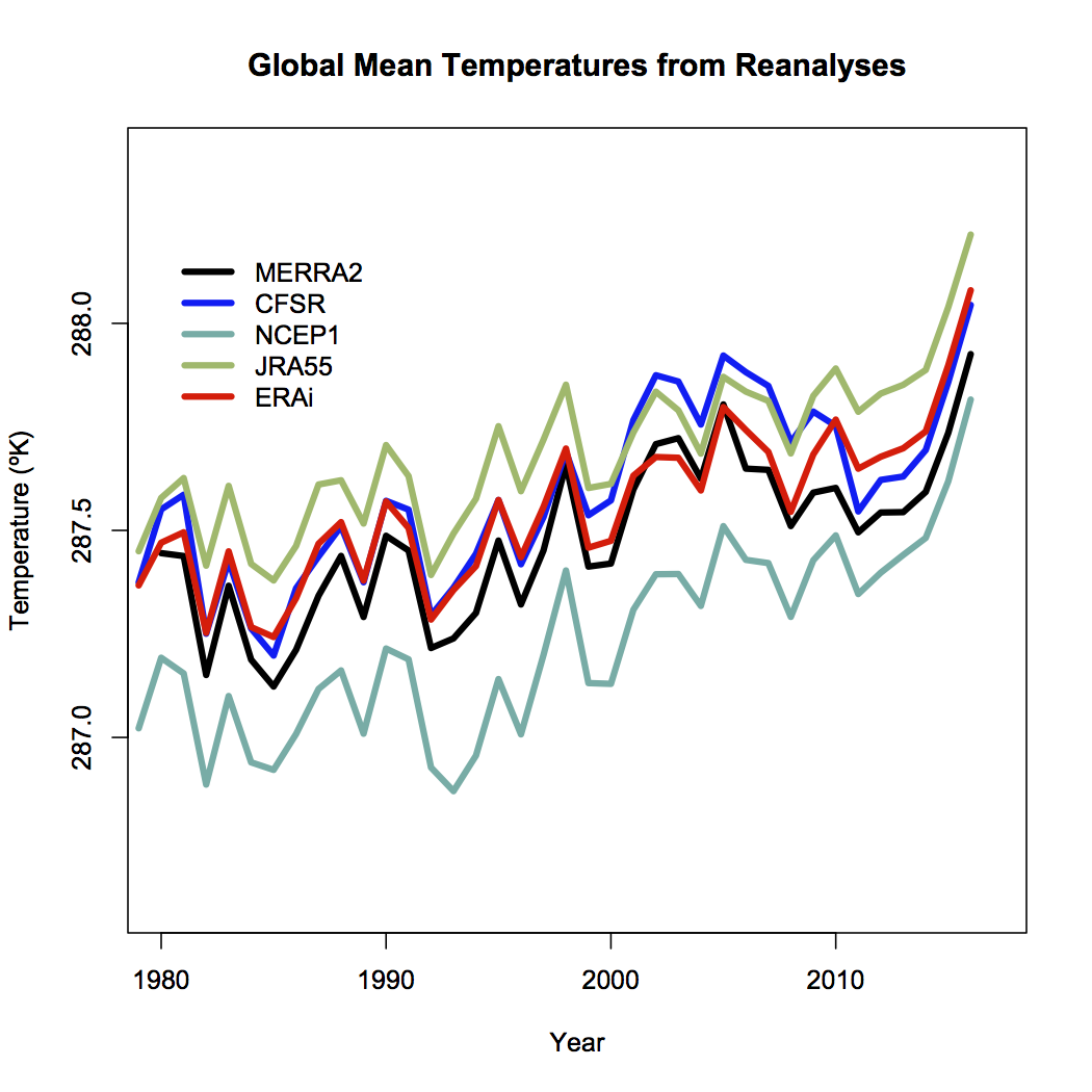
Differences will depend on resolution higher resolution models have better (and higher topography) and then will have slightly cooler temperatures (all else being equal which it isnt!), tuning, model structure etc. and cant really be discriminated using the pure (sparse) observations.
Coherence at the monthly scale is also quite good (though a little noisier), and I havent (yet) seen a good comparison of the coherence of the different products at the daily scale (note that the standard products (like GISTEMP, HadCRUT5 and NOAAv5) dont produce a daily product). One might anticipate that there is a similarity, but perhaps not a one-to-one correspondence on exactly which days were the warmest.
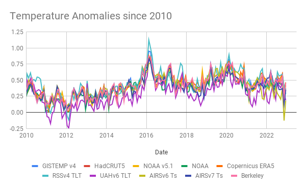
What are we seeing?
For the global temperature, its well established that the maximum is during the Northern Hemisphere summer. This sometimes comes as a surprise to people (why doesnt the opposing seasonality in the Southern Hemisphere cancel this out?), but it relates to the fact that there is a lot more land in the Northern Hemisphere. Since the seasonal cycle over land is much larger than over the ocean (smaller heat capacity, and less evaporation), that means that the seasonal variations in the north outweigh the variations in the south.
Thus the months of July and August are generally the warmest in the year, and consequently we expect the warmest days during those months and this is reflected in the CFS output (and in the ERA5 output also). The monthly variations are also reflected in the GISTEMP product which allows you to see the shifts from 1880 onward (about a 1ºC warming in each month since the late 19th C):
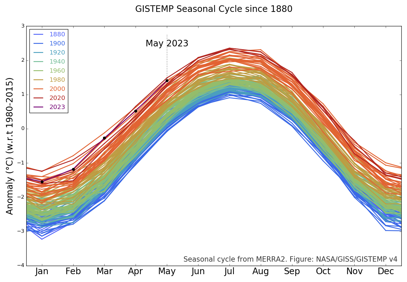
The station-based products are a little delayed with respect to the reanalyses, but they generally reflect the same patterns thus one should expect the June temperatures in NOAA, GISTEMP and HadCRUT5 to be the warmest June on record. Given too, that these temperatures are being driven by persistent warming in the oceans, increasingly juiced by the growing El Niño event in the tropical Pacific, records in July and August are also likely. This is of course increasing the odds for 2023 to be a record year (I would estimate about 50% at this point).
But the WSJ Opinion page says that theres no such thing as the global temperature!
Well, they would say that wouldnt they. [Narrator: there is, in fact, a perfectly well defined global mean of any two-dimensional field defined on the sphere, including temperature].
More generously, one might think that their argument (such as it is), is that the global mean isnt directly relevant for anyone. That is, no-one lives in the global mean, all impacts are local and driven by weather variations. But weve known for decades that the global mean change is a really good predictor (not perfect, but pretty good) of local impacts on heat waves, intense rainfall, drought intensity etc.
But lets be honest, its basically pure distraction and attempts to complicate something that is pretty basic:
The climate is warming, records are being broken, and we are increasingly seeing the impacts.
I know why the WSJ doesnt want you to realise this, but its not hard to see past their obfuscation.
___________
- Zeke Hausfather - With half the year now behind us, we estimate that 2023 annual temperatures have a roughly 81% chance to be the warmest year on record. https://twitter.com/hausfath/status/1678795147319062530

________
- Scientists say Canadian lake marks start of the Anthropocene
Earth's 4.5 billion-year history is divided into geological epochs that each typically span millions of years. On Tuesday, scientists announced that sediment at the bottom of a lake in Ontario, Canada, contains key indicators that the world has entered a new epoch called the Anthropocene.
The big picture: These researchers say humans, rather than a natural phenomenon like an asteroid strike, pushed the planet into this phase one in which Earth is being rapidly transformed.
- "[W]e are living in a new geological period, one in which the scale and power of human activities match or even exceed the scale and power of natural processes," Naomi Oreskes, a professor of the history of science, tells Axios via email.
Driving the news: A working group of the International Commission on Stratigraphy announced sediment from the bottom of Crawford Lake in the suburbs of Toronto contains markers of "human-caused planetary change" and "the socio-economic dynamics and violent histories that continue to drive the Anthropocene."
- But in defining a new epoch, the researchers are primarily focused on finding a geologic record of changes that occurred globally.
- Starting in the 1950s, the sediment record contains is artificial radionuclides from nuclear weapons testing that spread radioactive elements around the planet.
- Markers of industrialization and globalization nitrogen and mercury released from burning fossil fuels, microplastics pollution, nitrogen from fertilizers and other changes also spiked at different places across the globe in the mid-20th century.
How it works: A key element for designating an epoch is a "golden spike" a place on the planet where evidence of the start of a global change is found etched into rock, sediment or ice.
- Since 2019, teams of scientists have been studying sites around the world from a lake in the Toronto suburbs and a coral reef in Australia to peatland in Poland and the floor of the Baltic Sea in search of a location that best captures a permanent record of the alterations humans have made to planet as a whole.
- At Crawford Lake, soot, logging debris, pollen and other particles that carry fingerprints of human activities drop to the lake bottom.
- Their age can be determined by a layer of calcite that forms on top of sediment each year during the summer, the Washington Post's Sarah Kaplan writes, giving scientists an annual record going back centuries.
Why it matters: A new epoch would represent a new reference point for how scientists understand Earth's history and trajectory especially the impact of human-caused climate change.
- Epochs, eras and ages frame scientists' views of Earth's evolution the emergence of plants and the extinction of dinosaurs, the breakup of supercontinents and natural changes in global temperatures.
- They also provide a backdrop for researchers to predict future changes.
Between the lines: "[F]or Indigenous people, and for many colonized peoples across the globe, the end of their world already occurred," says Oreskes, who is a member of the working group.
- But it's also true "what we are facing today, in terms of the cascading and reinforcing crises of biodiversity loss, overpopulation, and climate change" is also "grave and worth addressing," she adds.
Where it stands: The new epoch isn't a done deal yet the Anthropocene is, for now, still just a proposal.
- Some scientists, including many who study climate change, already use the term widely. But it will be up to geologists to decide whether it is a unique epoch.
There is active debate about whether human-caused changes amount to a new epoch and, if so, when it began and how it should be defined.
- Some anthropologists point to a time hundreds of thousands of years ago when humans first harnessed fire, or to the dawn of agriculture.
- Others argue humans have been on Earth such a short time in geological terms, that we don't warrant our own epoch.
- "The Anthropocene inflates our own importance by promising eternal geological life to our creations," Peter Brannen wrote in the Atlantic.
- Some scientists have said the impact of humans should be categorized as an event, not an epoch.

https://www.axios.com/2023/07/11/ant...an-epoch-earth
-
17-07-2023, 11:35 AM #6699Thailand Expat

- Join Date
- Dec 2021
- Last Online
- @
- Posts
- 11,941
Jeeez, still trying to call me out. Whatever spamdreth. I’m not interested.
-
17-07-2023, 11:42 AM #6700Guest Member
- Join Date
- Sep 2008
- Last Online
- @
- Location
- left of center
- Posts
- 20,779
^the question remains
Originally Posted by S Landreth


 Reply With Quote
Thread Information
Users Browsing this Thread
There are currently 10 users browsing this thread. (0 members and 10 guests)
