
China lost plane images 'a mistake'

Transport Minister Hishammuddin Hussein: "We are in the middle of a crisis situation"
MH370 mystery
Chinese satellite images that were said to show debris from a missing Malaysian airliner were released by mistake, Malaysia's transport minister says.
Hishammuddin Hussein also denied a US report that the plane might have flown for hours after contact was lost with the Boeing 777.
Flight MH370 from Kuala Lumpur to Beijing went missing late on Friday, with 239 passengers and crew on board.
The minister said the disappearance of the plane was unprecedented.
Mr Hussein told reporters at Kuala Lumpur International Airport that the Chinese embassy in Kuala Lumpur had said Beijing's satellite images were released by mistake and "did not show any debris from MH370".

The three Chinese images appeared to show large, floating objects in the South China Sea
The grainy satellite images were released by China's State Administration of Science on Wednesday.
Mr Hussein said efforts to locate the aircraft were ongoing, promising to "spare nothing in our efforts to find MH370".
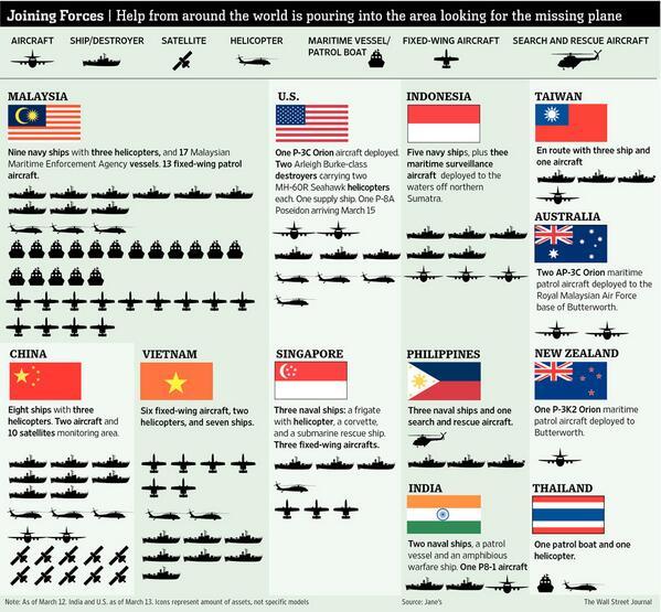
"There are currently 43 ships and 40 aircraft searching the South China Sea and Straits of Malacca" he said
BBC News - China lost plane images 'a mistake'

Results 526 to 550 of 4103
-
13-03-2014, 05:59 PM #526R.I.P


- Join Date
- Nov 2009
- Last Online
- 25-09-2014 @ 02:50 PM
- Location
- Mountain view
- Posts
- 40,028
-
13-03-2014, 06:09 PM #527Lord of Swine

- Join Date
- Feb 2012
- Last Online
- @
- Location
- Nahkon Sawon
- Posts
- 13,021
So we have China criticizing Malaysia for not doing enough but China then misleads the search efforts by releasing bogus pictures...
Meanwhile the US press is banging on about Malaysia while they themselves are publishing erroneous reports of how long the engines ran for.
Brilliant.
-
13-03-2014, 06:19 PM #528Days Work Done!


- Join Date
- Oct 2007
- Last Online
- Today @ 04:50 PM
- Location
- Roiet
- Posts
- 34,976
The whole thing has been a series of mistakes from day one. Rather than 100s of sources running off their mouths better to just say the search is on going. Originally Posted by Mr Lick
-
13-03-2014, 06:38 PM #529Member
- Join Date
- Oct 2013
- Last Online
- 12-09-2023 @ 10:55 PM
- Posts
- 854
Googled for some info, something to think about;
The seabed in South China Sea boasts its rich varieties of its topographic feature including the vast continental shelf, the continental slope and deep sea basin. The general topographical feature of South China Sea is characterized by its higher northwest part, lower southeast part, trapezoidally descending from peripheral part to the central part, continental shelf at the marginal part of the lozenge basin, the trapezoidally descending continental slope at the outer side of the continental shelf. At the central part of the South China Seas sea basin lies a flat deep sea basin. The sea bed ridge alternates with the lower part among which troughs and submarine trenches rise and islands as well as coral reefs are widely distributed.
Continental ShelfThe South China Sea continental shelf, being the gently extending part of Asian continental shelf, mainly lies in the north, west and south parts of the sea area. Because of its gentle topography, the peripheral water depth to the east of Pearl River mouth takes on an average depth of less than 200 meters, while to the west of the river mouth, the peripheral water depth increased with the widening of the water course with a general water depth of over 200 meters and the deepest of 379 meters. Broadly speaking, there are broader continental shelves in the northwest part and southwest part of the sea area, and at the same time, the relatively narrower part in the east.
South China Sea Continental SlopeBeing the natural extension of the continental shelf, South China Seas continental shelf lies on the peripheral part of the continental shelf, covering a rough area of 1.2 million kilometers which represents 49% of the total, it is the most broadly distributed topographical unit in the South China Sea area. The water depth is between 150 meters to 3,600 meters. There exists a terminal depth of 3,200~3,500 meters in the north east part and north part of the basin, while the other parts sees a terminal depth of 3,800~4,000 meters. Trapezoidally descending is one of the main characteristics of this area. According to the study, five sections of steps arising from South China Sea continental shelf as follows:
300--400-meter steps, such as Dongsha Step and Zhongshashangtai Step;Affected by the controlling of fragmentation structure in north-east, north-north, east-west and north-west directions, deep-sea troughs, sea-bed plateaus, slope terraces, sea-bed steep slope and sea-bed canyons are developed in this area.
1000--1500-meter steps, such as Xisha Step located outside of Pearl River mouth and in Xisha Islands;
1500--2000-meter steps, such as Nansha Step mainly located on the southern slope;
2200--2400-meter steps, developed from the western slope and Zhongshaxia Step;
2500--2800-meter steps, distributed on the deep-sea water steps at the rim of the slope.
South China Seas continental slope consists of the following parts:
(1) North Slope of the Central Basin,
(2) South Continental Slope of Hainan,
(3) South-southeast Slope of the Central Basin,
(4) East Slope of the Central Basin.
Abyssal plain of South China SeaAbyssal plain, covering a total area of 400 thousand square meters, is located east to the central part of South China Sea. Encompassed by the continental slope or island slope, Bashi Strait boasts a cannel of 2000-meter-deep connecting with the Philippines. Stretching in the direction of northeast-southwest direction, Abyssal plain of South China Sea runs up to 1500 kilometers with the broadest area of 820 kilometers. The plain stretches towards southeast part from the northwest with a 3400-meter-depth in the north part while 4200 meters in the south, quite a few parts exceeds 4400 meters in depth. The plains average ratio of slope is 1 to 1.3, but the ratio of slope in the north central part of the basin is only 0.3 to 0.4.
There distributed isolated submarine mountains up to 3400~3900 meters high, which is composed of all the isolated peaks dotted in the basin area. There are 27 sea mounts over 1000 meters high as well as more than 20 sea knolls with the heights ranging from 400 meters to 1000 meters on the abyssal plain.
Respectively on the northeast end and southwest end of the abyssal plain lie two deep-water valley floors. At the valley entrance, as at the ends of all submarine valleys, are piled with different abyssal caves. Some of them have been erected to be northeast-toward small scale ridges.
The abyssal plain of South China Sea, in terms of its topographical structure, is the part forming from the deep layer of basalts compensating upwelling caused by the tearing occurred at the rim of Asian continent. There still exists a series of volcano erupting activities along the grand northeast crevice in the central and east part of the plain.
The Topographic Feature of the Sea-bed in South China Sea
-
13-03-2014, 08:10 PM #530Banned
- Join Date
- Jul 2012
- Last Online
- 09-05-2021 @ 03:25 AM
- Posts
- 33,644
This is the back of a 10 ringgit note for those who haven't seen one, there is a newer one out but there's still loads of these in circulation.
Eerie

-
13-03-2014, 08:31 PM #531Thailand Expat

- Join Date
- Feb 2006
- Last Online
- @
- Posts
- 15,842
It's a little bit further south that where we have all the data, but not too far. Originally Posted by Ronin

The Gulf Of Thailand down to the Malaysian border is sand, soft and relatively flat.
No more than 100m deep.
-
13-03-2014, 09:42 PM #532Thailand Expat

- Join Date
- Mar 2007
- Last Online
- 21-10-2023 @ 08:08 AM
- Location
- Way, Way South of the border now - thank God!
- Posts
- 32,680
Well done, Thailand
-
13-03-2014, 10:52 PM #533Excommunicated

- Join Date
- Apr 2006
- Last Online
- Today @ 05:08 PM
- Posts
- 24,824
Thailand
1 patrol boat and 1 helicopter
probably no money for fuel as it would have been spent on shopping trips to london and hong kong
-
13-03-2014, 11:00 PM #534Thailand Expat

- Join Date
- May 2012
- Last Online
- @
- Location
- UK
- Posts
- 4,354
Makes you appreciate what we have in Europe ..
100% cooperation, trust between nation states
If this had happened of the coast of France all neighbours would be pooling resources.
The SE Asians with their savage backwards face-saving have probably fcked any chance of closure for 200 families.
Interestingly enough the Malaysian Airforce has expensive top of the range export fighters like Sukhoi SU-30s and F-18s but they don't have a couple of cheap maritime surveillance aircraft like the P-8 which would have been invaluable in the few hours after the loss
Malaysia Strong!!!
Malaysia have F-18!!
Malaysia have Face!!
-
13-03-2014, 11:39 PM #535Thailand Expat

- Join Date
- Sep 2009
- Last Online
- @
- Posts
- 97,004
Interesting words from the US:
US Officials Have 'Indication' Malaysia Airline Crashed into Indian Ocean - ABC NewsU.S. officials have an "indication" the missing Malaysia Airlines jetliner may have crashed in the Indian Ocean and is moving the USS Kidd to the area to begin searching.
It will take another 24 hours to move the ship into position, a senior Pentagon official told ABC News.
"We have an indication the plane went down in the Indian Ocean," the senior official said.
And no sooner do ABC report that than NBC report this:
Jesus how can you trust any of them to provide reliable information?!The guided-missile destroyer USS Kidd is moving to the Strait of Malacca — west of the Malaysian peninsula — to continue the search for the missing airliner, senior defense and military officials told NBC News.
The move comes at the request of Malaysian authorities, but not because they have any specific evidence or believe that is where the plane crashed.
The Kidd and a second destroyer, USS Pinckney, have been searching waters just south of the Gulf of Thailand where the airliner was last tracked before it vanished without a trace early Saturday. A US Navy P-3 anti-submarine warfare plane has already been searching the Strait of Malacca.
The officials denied that the Kidd has been ordered to the Indian Ocean, contrary to a report that the U.S. had an "indication" the jetliner may have crashed there.
http://www.nbcnews.com/storyline/mis...ing-jet-n51931Last edited by harrybarracuda; 14-03-2014 at 12:34 AM.
-
13-03-2014, 11:45 PM #536Thailand Expat

- Join Date
- Feb 2011
- Last Online
- Today @ 04:46 PM
- Location
- In the EU
- Posts
- 12,328
That would be a good reason for grounding the 777 fleet until they were all checked. Originally Posted by Warrior
Boeing won't allow that without lots of kicking and screaming.....
I would have expected the crew to be okay until the pressure dropped to klaxon warning though.
-
13-03-2014, 11:51 PM #537Thailand Expat
- Join Date
- Sep 2009
- Last Online
- @
- Posts
- 97,004
Helios 522. Originally Posted by Troy
Pentagon says U.S.S. Kidd is moving to the Strait of Malacca.
-
14-03-2014, 12:21 AM #538Thailand Expat
- Join Date
- Sep 2009
- Last Online
- @
- Posts
- 97,004
I can tell you how old it is. Look at the date. Originally Posted by Little Chuchok
-
14-03-2014, 12:25 AM #539Thailand Expat
- Join Date
- Sep 2009
- Last Online
- @
- Posts
- 97,004
Just one small point. The Americans will remember how the Egyptians did their best to cover up the suicide by pilot that took down Egypt Air 990.
What price them wanting to recover the FDR and CVR first and copy the contents before handing them to the Malaysians, who for damned sure would want to cover up such an event (and obviously that event is hypothetical but not ruled out at the moment)?
And of course the Malaysians would want to pin it on Boeing, which would not be good news.
-
14-03-2014, 01:48 AM #540Thailand Expat
- Join Date
- Mar 2011
- Last Online
- 25-03-2021 @ 08:47 AM
- Posts
- 36,437
Yes...Gallowspole suggested that on page 20, posts #496, 497... Originally Posted by Necron99
-
14-03-2014, 02:18 AM #541Thailand Expat

- Join Date
- Oct 2008
- Last Online
- @
- Posts
- 6,429
On the plus side they are running out of oceans and sea's to check.
Narrowing the search down nicely,on the serious side hope the solve the mystery soon,for the families sake.
-
14-03-2014, 03:23 AM #542Thailand Expat
- Join Date
- Sep 2009
- Last Online
- @
- Posts
- 97,004
Originally Posted by klong toey
Narrowing it down to 27,000 sq nm?
Ooooooooooooo Kkkkkkkkkkkkkkkk.....

-
14-03-2014, 03:36 AM #543Thailand Expat
- Join Date
- Mar 2011
- Last Online
- 25-03-2021 @ 08:47 AM
- Posts
- 36,437
Can you imagine, if by some freak chance (like seven 19's in a row on roulette), the plane landed safely and they all survived?...
More than the Chilean miners coming out of their would-be grave, they would be sublime heros, all...
-
14-03-2014, 04:00 AM #544Thailand Expat

- Join Date
- Dec 2012
- Last Online
- 28-10-2019 @ 03:54 AM
- Location
- England
- Posts
- 10,940
There is nowhere where a runway large enough to land safely that it would be seen,it would be spotted by many with mobile phones or wifi and soon a message would be sent.
North Korea may be the only suspect,but their air space must be the most heavily watched in the world.
-
14-03-2014, 06:57 AM #545Days Work Done!
- Join Date
- Oct 2007
- Last Online
- Today @ 04:50 PM
- Location
- Roiet
- Posts
- 34,976
They went home along with Vietnam. Told Malaysians they would be back when they get their shit together. Originally Posted by OckerRocker
-
14-03-2014, 07:06 AM #546Thailand Expat

- Join Date
- Jun 2013
- Last Online
- @
- Location
- 7th Military Circle
- Posts
- 2,985
havin' a laugh
Originally Posted by prawnograph
Updated: Friday March 14, 2014 MYT 7:25:00 AM
PETALING JAYA: Hospital Kuala Lumpur (HKL) has not suspended the three nurses for spoofing bomoh Ibrahim Mat Zin in a photo that has since gone viral on social media.
However, a detailed investigation is being conducted, said HKL director Datuk Dr Zaininah Mohd Zain.
The three nurses were among many who had parodied the "magic carpet" set up by Ibrahim and his followers at KL International Airport.
-
14-03-2014, 07:10 AM #547Thailand Expat
- Join Date
- Jun 2013
- Last Online
- @
- Location
- 7th Military Circle
- Posts
- 2,985
more variations on the bomoh antics

are they the bamboo binoculars?

-
14-03-2014, 07:27 AM #548Thailand Expat
- Join Date
- Mar 2011
- Last Online
- 25-03-2021 @ 08:47 AM
- Posts
- 36,437
Gotta love it...But sorry for those involved with the tragedy...
-
14-03-2014, 07:50 AM #549.

- Join Date
- Mar 2012
- Last Online
- @
- Posts
- 21,286
The latest angle is that the plane might have continued undetected for 4 more hours. This means the plane could be located 2000 miles from its last detected position.
The USA is sending a ship to look in the Indian Ocean.Last edited by Neverna; 14-03-2014 at 09:59 AM.
-
14-03-2014, 08:18 AM #550.
- Join Date
- Mar 2012
- Last Online
- @
- Posts
- 21,286
Officials: Malaysia Airlines Flight 370 plane may have flown for hours - CNN.com
Officials: Malaysian plane may have flown long after last contact

 Reply With Quote


Thread Information
Users Browsing this Thread
There are currently 1 users browsing this thread. (0 members and 1 guests)
