
Worlds a strange place. I have been considering 3 places to spend next years storm season. Evan has nailed one option, and is heading for the second. The third is way to the east in French Poly.
Yesterday Apia in Samoa got devastated and now it is heading towards Fiji. If this was heading towards the USA it would be front page news. Equally devastating if not more it does not get a mention in our western press. Since I hope to be a Pacific islander next year (got to get off the same continent as Socal) I post this because while I look at these places with rose coloured glasses, real people have real lives. whatching some of the video i was struck by the devastation and that people had had lost so much. Now this natures hard man is heading towards Fiji.
One thing that has impressed me is tat one of the worlds small nations NZ has stepped up to the plate without any hesitation.

Results 1 to 22 of 22
Thread: Cyclone Evan
-
15-12-2012, 03:09 PM #1Ocean Transient


- Join Date
- Apr 2010
- Last Online
- 23-07-2024 @ 03:25 AM
- Location
- Untied from dock. Heading South Down West Coast of Canada.
- Posts
- 3,631
Cyclone Evan
-
15-12-2012, 03:11 PM #2Thailand Expat

- Join Date
- Aug 2007
- Last Online
- @
- Posts
- 1,411
Gets a mention in our western press ............................ Originally Posted by Sailing into trouble
-
15-12-2012, 03:16 PM #3Ocean Transient
- Join Date
- Apr 2010
- Last Online
- 23-07-2024 @ 03:25 AM
- Location
- Untied from dock. Heading South Down West Coast of Canada.
- Posts
- 3,631
NZ to send assistance to Samoa for Cyclone Evan relief
UPDATED 19:00
Published: 6:40AM Saturday December 15, 2012 Source: ONE News
Email this article Print this article Text size+-
New Zealand will assist Samoa in the aftermath of Tropical Cyclone Evan, after the Pacific island nation requested help.
The New Zealand Government will help carry out surveillance and health assessments, as well as donating $50,000 dollars towards the relief effort, it announced today.
Foreign Affairs Minister Murray McCully said his department is preparing to assist with the immediate response effort.
Story continues below...
View Photos
Photogallery: Cyclone in Samoa(18 photos)
Related
22:13 Fiji braces as Cyclone Evan picks up momentum video photos
Cyclone Evan rips through Samoa (2:14)
Raw video: Cyclone devastation in Samoa (0:31)
"At the request of the Samoan Government, New Zealand will provide a P3 Orion to undertake aerial surveillance and environmental health assessment expertise," he said.
"We have also made available $50,000 to assist with the on-the-ground response."
Samoan police confirmed to ONE News that four people, including a three-year-old girl, were killed when the cyclone tore through the country on Thursday afternoon. Seven people are still missing, including a number of children.
Cyclone Evan battered Samoa with winds of up to 190km/h, wreaking devastation to buildings and critical infrastructure. Power lines are down and there has been flash flooding in many areas.
Village destroyed
ONE News Pacific correspondent Barbara Dreaver saw the devastation first-hand, in the village of Magiagi, near Apia.
The river that runs through it broke its banks, sweeping away everything in its path, our correspondent says.
Advertisement
Survivors told her how they formed a human chain to pull children to safety.
"When the storm hit our side here, all the families tried to protect their houses and their children and their parents," said Solo Fa'auliuli.
But dozens of families in Magiagi lost everything they own as the water level rose by up to five metres.
A massive clean up operation is now underway across the country, even as police search for the missing.
"Our heartfelt condolences go out to the people of Samoa as they begin to come to terms with the loss of life and damage caused," McCully said.
He added that assessment of the damage is on-going and New Zealand will consider additional assistance if requested.
It comes as the New Zealand Red Cross deployed a senior representative to liase with its Samoan counterparts and offer additional assistance if needed.
Glenn Rose flew from Auckland Airport this morning after speaking with the Samoan Red Cross. It was the first flight to land in the capital, Apia, since the cyclone tore through the country.
He will help establish the extent of the damage and immediate humanitarian needs, as part of the Pacific Tropical Cyclone Response Plan.
Fiji braces
Meanwhile, having devastated Samoa, Cyclone Evan is now on a direct path towards Fiji, with warnings it could become even more vicious.
The Category Three Tropical Cyclone is expected to be upgraded to a Category Four over the weekend as it draws nearer to the country.
The Fiji Meteorological Service has warned the cyclone could threaten northern parts of Tonga on Saturday and reach Fiji by Sunday or early Monday.
Fiji's Prime Minister has warned people to stay at home, with police disaster management teams on standby.
The cyclone is set to disrupt the travel plans of hundreds of New Zealanders heading to Fiji in the coming days.
McCully advised New Zealand travellers to contact their airline or travel agent to about flight and accommodation bookings.
Those interested in offering assistance to Samoa are urged to donate to a humanitarian agency involved in the response, for example the Red Cross Pacific Disaster Response Fund..
-
15-12-2012, 03:18 PM #4Ocean Transient
- Join Date
- Apr 2010
- Last Online
- 23-07-2024 @ 03:25 AM
- Location
- Untied from dock. Heading South Down West Coast of Canada.
- Posts
- 3,631
Tropical cyclone Evan upgraded to a category four system
Posted at 22:57 on 14 December, 2012 UTC
The weather service in Samoa says tropical Evan has moved away from the capital, Apia, and strong winds are now buffeting the smaller islands off the northern coast of Savai’i.
It says the rain has eased and damage assessment teams should be able to begin work today.
The police in Samoa say two people have been killed.
Two children are missing presumed drowned, and at least five other people are also missing.
The assistant chief executive of the Meteorological Division Mulipola Ausetalia Titimaea says the cyclone is now about 100 kilometres away from Apia.
“The current position is north-north west of Apia, it’s must closer to Savaii at this time. The tropical cyclone is moving west north west at a speed of 6 miles per hour at this time we are still monitoring the situation but there is very little chance of looping back to the islands.”
Samoa’s Disaster Management Office says about two thousand people evacuated from flooding have sought refuge in emergency shelters around Apia.
A spokesperson, Filomena Nelson, says more than ten emergency shelters have been established.
“The government is providing that and also relief supplies like food and non-food items mainly blankets and clothing. We have more than 2000 people in the shelters that we have established but other people have evacuated to their other relatives who live on higher ground.”
She says today, damage assessment teams will begin inspecting the devastation on the island of Upolu.
She says search and rescue teams have reported damage to houses, roads and the water and electricity infrastructure.
Filomena Nelson says there’s likely to be extensive damage to the island’s agriculture.
“Most likely we will go out and do damage assessment throughout the island of Upolu first because at this stage the cyclone has moved over the island of Savaii so we will not be able to go over there until the cyclone is well away from us.”
The storm is expected to hit Fiji next, and the authorities are preparing for the worst.
The Fiji metservice says tropical cyclone Evan is intensifying as it moves towards Fiji.
It says the cyclone has now been upgraded to a category four system with winds close to the centre of up to 165 kilometres an hour with momentary gusts of 230 kilometres an hour.
A tropical cyclone alert and a strong wind warning is now in force for Fiji’s Vanua Levu, Taveuni and nearby smaller islands and the Northern Lau group.
A damaging heavy swell warning is also in force for Vanua Levu, Taveuni and nearby smaller islands and Northern Lau group.
The lead forecaster at the Fiji metservice, Misaeli Funaki, says warnings have also been issued for the Niua group of islands in Tonga.
He says Fiji should start feeling tropical cyclone Evan by Sunday.
“The eye of Evan will move towards the north of us and the winds are still going to be experienced by Fiji. We are looking at the later part of Sunday we should be feeling it in Fiji, mainly to the islands which we are warning for and as it comes in we will probably have to include the other islands.”
Misaeli Funaki says they expect tropical cyclone Evan to leave Fiji waters on Tuesday.
The Ministry of Information says Evan is likely to be the most powerful cyclone to hit Fiji since 1993.
Fiji’s interim prime minister, Commodore Frank Bainimarama, addressed the nation saying Evan will affect the whole country.
“It has winds of up to 180 kilometres power which may intensify, and if the weather forecasters are correct, it will affect Fiji in a very damaging way bringing about destructive winds and flooding, fellow Fijians I can not stress enough how serious this is, every Fijian will be affected.”
Fiji’s interim leader, Frank Bainimarama.
-
15-12-2012, 03:23 PM #5Ocean Transient
- Join Date
- Apr 2010
- Last Online
- 23-07-2024 @ 03:25 AM
- Location
- Untied from dock. Heading South Down West Coast of Canada.
- Posts
- 3,631
-
15-12-2012, 03:46 PM #6Ocean Transient
- Join Date
- Apr 2010
- Last Online
- 23-07-2024 @ 03:25 AM
- Location
- Untied from dock. Heading South Down West Coast of Canada.
- Posts
- 3,631
Does it Mid? Maybe we do not pay attention to small nations. Originally Posted by Mid

I'll give you an example. As you know I live in Canada. One of the better US imports has been Costco. Good product, good employer and often good price. After Sandy at the check out you were invited to donate to the Red cross relief effort in the US.
The Richest nation in the World! now did Sandy just do damage in the US? Found it rather shallow and also worrisome that we can be exclusive in our care. Or is it a way of programing us to look inward?
-
15-12-2012, 03:50 PM #7Thailand Expat
- Join Date
- Aug 2007
- Last Online
- @
- Posts
- 1,411
suspect you were a victim of demographics there and not something thought through by an entity capable of doing so .
As to Evan , yes Oz keeps a weather eye on our neighbours in the pacific and assists when and as required .
-
15-12-2012, 05:30 PM #8Member

- Join Date
- Apr 2012
- Last Online
- 20-02-2013 @ 09:09 AM
- Posts
- 424
Samoa was a NZ territory 1914-1962 (German before that), there were 50th independence events this year. Originally Posted by Sailing into trouble
Last census had 180,741 people living in Samoan, NZ census same year had 131,100 Samoans resident in NZ. Samoan is the second-most commonly used language in Auckland, ahead of Maori. more
Expect NZ will provide a lot more support as/when needed. They provided over $24m aid 2011-2
-
15-12-2012, 09:01 PM #9Banned
- Join Date
- Oct 2008
- Last Online
- 03-06-2014 @ 09:01 PM
- Posts
- 27,545
If it's the devastating storms you're attempting to avoid.....your third option would suffice, as the more southeasterly regions are visted [hurricanes] only occasionally. French Polynesia.
-
15-12-2012, 09:50 PM #10Thailand Expat

- Join Date
- Mar 2006
- Last Online
- 05-04-2025 @ 12:43 PM
- Posts
- 5,626
Samoa is beautiful, I spent time there 10 years ago.
Had 3 weeks touring Fiji this year.
-
15-12-2012, 10:23 PM #11Banned
- Join Date
- Oct 2008
- Last Online
- 03-06-2014 @ 09:01 PM
- Posts
- 27,545
Try the Marquesas.... Originally Posted by The_Ghost_Of_The_Moog
Still paradise on earth.
One of the few spots left.
-
15-12-2012, 11:26 PM #12Ocean Transient
- Join Date
- Apr 2010
- Last Online
- 23-07-2024 @ 03:25 AM
- Location
- Untied from dock. Heading South Down West Coast of Canada.
- Posts
- 3,631
Strongly considering the marquesas, Thai Mrs is not allowed to stay, she was considering going back to Thailand to see her mother until she saw youtube clip of Poly dancers! Now she has decided she will stay close:-)
-
15-12-2012, 11:28 PM #13Ocean Transient
- Join Date
- Apr 2010
- Last Online
- 23-07-2024 @ 03:25 AM
- Location
- Untied from dock. Heading South Down West Coast of Canada.
- Posts
- 3,631
http://www.aljazeera.com/mritems/Ima...4621734_20.jpg
Cyclone Evan on path to hit Fiji
Updated 15 December 2012, 23:24 AEST
Pacific correspondent Campbell Cooney, wires and staff
Meteorological services across the Pacific are keeping a close eye on Cyclone Evan as it makes its way towards Fiji.
Severe Tropical Cyclone Evan forecast track map issued by the Fiji Meterological Service on December 15, 2012. (Credit: ABC)
Meteorological services across the Pacific are keeping a close eye on Cyclone Evan as it makes its way towards Fiji.
The latest weather bulletin puts the cyclone off the north-west coast of Samoa, moving west at around 15 kilometres an hour.
Its current path means it is no longer expected to affect Tonga and cyclone warnings have now been cancelled for the northernmost island of Niuafo'oh.
However, it could generate storm conditions in the French Territory of Wallace and Futuna, as well as affect the New Zealand Territory of Tokelau.
Evan is currently rated as a category four cyclone, but it is expected to intensify as it moves closer to Fiji.
The cyclone is due to hit Fiji on Sunday night.
Emergency preparations are currently underway and Fiji's military is on standby.
The interim government say troops in all parts of the country are ready to help with recovery assistance and search and rescue operations.
Meanwhile, a state of emergency has been declared in Samoa, where the cyclone has caused widespread damage and killed at least two people.
Tonga's head of the Ministry of Infrastructure, Ringo Faoliu, says there is a good possibility it will miss his country and its remote islands altogether.
He says the cyclone is 100 kilometres away from one of Tonga's northern-most islands in the Niue group and has already passed the other two in the chain.
High alert
Fiji's interim Prime Minister Commodore Frank Bainimarama has addressed the nation, warning Cyclone Evan will affect the entire country.
"It has winds up to 180 kilometres an hour which may intensify, and if the weather forecasters are correct it will affect Fiji in a very damaging way, bringing about destructive winds and flooding," he said.
"I cannot stress how serious this is, every Fijian will be affected."
Commodore Bainimarama is urging people to remain calm, look after the elderly and disabled, cancel social events, secure their properties and avoid travel and alcohol until the storm threat diminishes.
Fears that the cyclone could return and hit Samoa again have eased.
Neville Koop, climate adviser to the Secretariat of the Pacific Regional Environment Program based in Suva, says the storm is on course to hit Fiji.
He says Cyclone Evan could intensify to a category four or five cyclone.
"At this stage everyone should just expect that this will be a very destructive cyclone and it could lead to quite catastrophic impacts for those people who are subject to the cyclone," Mr Koop said.
"Cyclones of this intensity bring winds gusting to 200 kilometres an hour so even well-constructed buildings are subject to failure, roofs flying off, that sort of thing."
Evacuations
Fiji's Permanent Secretary for Information, Sharon Smith-Johns, told Pacific Beat evacuations gave begun and preparations are well underway.
Audio: Fiji prepares for the arrival of Cyclone Evan (ABC News)
"It will be quite destructive. We've seen what's happened in Samoa and all we can do is be prepared here lucky we've had a week's notice of this," she said.
"All the agencies have been deployed, emergency services on standby, evacuation centres are open, rations have gone out.
"Now it's just a matter of continuing to clean up our own backyards and putting cyclone shutters up and waiting."
Ms Smith-Johns says many people have fled to higher ground.
"There are people that have already taken precautions. They know that they live in flood prone areas and they're moving to higher ground or moving in with relatives, so there is quite a lot of movement around Suva...and in the rural areas."
Video: Fears Evan could intensify as it heads to Fiji (ABC News)
-
16-12-2012, 02:06 PM #14Hifaluten Member

- Join Date
- Aug 2005
- Last Online
- 08-02-2019 @ 10:23 PM
- Location
- Fiji Islands
- Posts
- 3,186
The main tourist hub of Nadi hasn't seen a system of this significance for a long while. Compounding the effects of rain on flash flooding are current spring tides. If things play out as predicted it seems rain from the storm will hit low laying lands dead on one of our biggest tides this year. I had been playing this down but it now looks like this will be bad for Fiji - we are quite safe on the east of Viti Levu but expecting a few days of gale force winds and likely loss power and water for a while. Originally Posted by latest internal update
Last edited by Wayne Kerr; 16-12-2012 at 02:31 PM.
Old travel threads: Outback, Australia | Taytay, Philippines | Busuanga, Philippines | Isaan, Thailand | Phu Quoc Island, Vietnam
-
16-12-2012, 02:11 PM #15Hifaluten Member
- Join Date
- Aug 2005
- Last Online
- 08-02-2019 @ 10:23 PM
- Location
- Fiji Islands
- Posts
- 3,186
Latest images
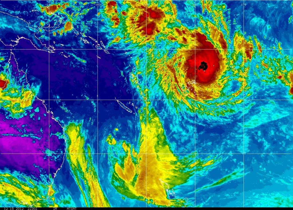


-
16-12-2012, 02:20 PM #16Thailand Expat
- Join Date
- Aug 2007
- Last Online
- @
- Posts
- 1,411
ouch , hang on tight WK
-
16-12-2012, 03:57 PM #17Ocean Transient
- Join Date
- Apr 2010
- Last Online
- 23-07-2024 @ 03:25 AM
- Location
- Untied from dock. Heading South Down West Coast of Canada.
- Posts
- 3,631
Wallis Island got a direct hit. They have been out of contact as the secured their Sat Dishes until the storm passes.
Storm now could become a Cat 5Much of Fiji is now under curfew as it awaits Cyclone Evan - which is threatening to become a devastating category five storm.
Radar pictures show that Evan, which devastated Samoa on Thursday night, is about to hit Fiji tonight and into tomorrow.
It is not known what happened to the 15,000 people of the French islands of Wallis and Futuna, which Evan passed over today.
The upgrade came as Evan was on top of Wallis Island, part of the French territory of Wallis and Futuna. The islands, the only kingdoms within the Republic of France, are now completely cut off.
Authorities there usually take down satellite dishes as cyclones pass over.
The military commissioner for Fiji’s northern district, which includes Vanua Levu, Colonel Ilai Moceica, this afternoon imposed a curfew, saying it was necessary to save lives.
Meanwhile the Fiji Navy has warned all seafarers that travelling during disasters not only threatens the lives of those at sea, but also the Fiji Navy.
The latest warning from the Fiji Meteorological Service has issued storm and gale warnings across a wide area of Fiji, including the Yasawa and Mamanuca areas, popular with tourists.
All tourists at island resorts off the western coast of Viti Levu have been evacuated to the Nadi area. The service is warning that “destructive winds” may begin several hours before the cyclone centre arrives around midnight.
Weather forecasters are predicting that super cyclone Evan will hit New Zealand's Northland and Auckland area toward the end of the week.
Samoa, which was savaged by the storm on Thursday night, has four confirmed dead and eight people missing from fishing boats.
Maritime New Zealand's Rescue Coordination Centre says a Royal New Zealand Air Force P3 Orion has sighted wreckage of a fishing boat, one of three they are looking for which held up to eight men.
It is washed up on the small volcanic island of Apolima, between Upolu and Savai'i but there is no sign of the crew.
Mission coordinator Tracy Brickles says a 30-year-old skipper of one of the boats has been found alive on nearby Monono Island. He has yet to be spoken to by Samoan Police but is believed to have clung to flotsam after the boat tipped over some time on Friday.
The missing boats are all twin-hulled 9m boats fitted with outboard motors.
A French Navy Guardian aircraft from Tahiti has joined the search.
Fiji's military regime has mobilised its large army ahead of Evan's arrival off the north eastern end of Vanua Levu. Track prediction charts have so far kept the eye of the storm out to sea but in the last 12 hours predictions have it much closer to land.
The worst of the storm is likely to hit early Monday morning.
Senior Weather Forcaster Misaele Funaki says heavy rain currently fell in the north eastern part of Fiji and wind will pick up.
"We should be prepared for the winds to increase from later today," he told state radio.
Dozens of evacuation centres have been set up around the country. The Fiji Meteorological Service is warning of five metre surges. "This can be made worse by high tide," it says.
"A Category 4 cyclone can result in roofing failures (roofs blown away) as well as extensive damage to doors and windows. Low lying escape routes may be cut off. Major damage to lower floors of buildings near the coast can be expected.
"Land near the coast that is lower than three metres above sea level may be flooded."
Fiji's military leader Voreqe Bainimarama has already warned the storm is an "impending disaster" and urged its people to take it seriously.
Meanwhile in Samoa a National Disaster Council under Prime Minister Tuilaepa Sailele says over 3200 people have been displaced as their homes were destroyed, mainly by heavy flooding.
Many of those displaced are from Lelata, Ma'agao, Leone, Faatoia and Matautu areas. Their homes were affected by the heavy flooding of the Vaisigano River.
The Commissioner of Police, Lilomaiava Fou Taioalo reported that four people are confirmed dead due to the cyclone, with eight people missing - including five fishermen reportedly missing at sea.
One fisherman, cast adrift, managed to swim to the coast at Salelologa and was saved.
The New Zealand government has approved $50,000 as well as offering aerial survey support, the United States US$50,000 through the Red Cross Society and a grant of US$50,000 from the United Nations Development Program as well as technical assistance in damage assessments.
In an unusual speech to the nation, Tuilaepa told the largely Christian state that there was a time for every season, and that God balances all things.
"The most poignant concerns that are distressing world leaders at the moment are the disastrous changing weather patterns that will allow the occurrences of cyclones, tsunamis, earthquakes, flooding and other disasters, which all emanates from man abusing the garden that God appointed him to tend, such as the mindless cutting of trees excessively warming the environment resulting in disasters not often experienced before," he said.
He said deforestation near rivers and streams led to Samoa's disaster.
"Likewise the extreme deforestation near rivers and streams which, consequently, now results in the loss of lives and the destruction of homes nearby due to flash floodings."
- © Fairfax NZ News
-
17-12-2012, 11:51 AM #18Ocean Transient
- Join Date
- Apr 2010
- Last Online
- 23-07-2024 @ 03:25 AM
- Location
- Untied from dock. Heading South Down West Coast of Canada.
- Posts
- 3,631
This site has several news reports. Now up to a five and much closer than first predicted. Wayne keep yer head low!
VIDEO: Power outages as Cyclone Evan hits Fiji - World - Video - 3 News
-
17-12-2012, 11:40 PM #19Ocean Transient
- Join Date
- Apr 2010
- Last Online
- 23-07-2024 @ 03:25 AM
- Location
- Untied from dock. Heading South Down West Coast of Canada.
- Posts
- 3,631
This is the spot we hope to be next year at this time. Sort of spookie.
Last edited by Sailing into trouble; 17-12-2012 at 11:55 PM.
-
18-12-2012, 06:09 AM #20Ocean Transient
- Join Date
- Apr 2010
- Last Online
- 23-07-2024 @ 03:25 AM
- Location
- Untied from dock. Heading South Down West Coast of Canada.
- Posts
- 3,631
Sorry double post
Last edited by Sailing into trouble; 18-12-2012 at 06:14 AM.
-
12-09-2013, 12:33 AM #21Thailand Expat

- Join Date
- Aug 2011
- Last Online
- @
- Location
- Absinthe Without Leave
- Posts
- 25,533
Evan's above
-
15-09-2013, 03:38 AM #22Newbie
- Join Date
- Sep 2013
- Last Online
- 14-10-2013 @ 03:12 PM
- Posts
- 1
A tropical cyclone alert and a strong wind warning is now in force for Fijis Vanua Levu, Taveuni and nearby smaller islands and the Northern Lau group.
A damaging heavy swell warning is also in force for Vanua Levu, Taveuni and nearby smaller islands and Northern Lau group.: sexy:
 [/SIGPIC]

 Reply With Quote
Thread Information
Users Browsing this Thread
There are currently 1 users browsing this thread. (0 members and 1 guests)
