
That explains it then. Supposed to be a good camera, from my limited knowledge.Originally Posted by dirtydog


Results 51 to 75 of 206
Thread: Wayne Kerr Does the Desert
-
19-09-2007, 03:31 AM #51Thailand Expat


- Join Date
- Dec 2006
- Last Online
- 21-07-2019 @ 04:40 PM
- Location
- Yorkshire
- Posts
- 4,067
-
19-09-2007, 08:07 AM #52Thailand Expat


- Join Date
- Mar 2007
- Last Online
- 07-12-2022 @ 03:12 PM
- Posts
- 26,746
Originally Posted by dirtydog
Don't need one mate,
Aussies are tough bastards and theres no need to shit.
-
19-09-2007, 10:23 AM #53Member

- Join Date
- Jun 2007
- Last Online
- @
- Posts
- 365
^ in the absence of toilet facilities, aussies have learned to use gum leaves, sticks , soft pieces of bark, we are the masters of adaptation and survival in the bush. Anyway, it beats the hell out of shitting in your pants or using your fingernail Originally Posted by dirtydog

Last edited by The Basket Weaver; 19-09-2007 at 10:31 AM.
-
19-09-2007, 10:32 AM #54Thailand Expat
- Join Date
- Feb 2006
- Last Online
- @
- Posts
- 38,456
^ Plenty of dingo's, lizards and croc's to clean up afterwards anyway.

-
19-09-2007, 10:43 AM #55I am in Jail
- Join Date
- Apr 2007
- Last Online
- 22-11-2011 @ 08:27 AM
- Location
- Christian Country
- Posts
- 15,017
Um, no. At current exchange rates and expecting that the liters/gallon conversion formula is unchanged, the price would be just over US$6.40 a gallon or about A$7.60. Originally Posted by terry57
-
19-09-2007, 10:48 AM #56Member
- Join Date
- Jun 2007
- Last Online
- @
- Posts
- 365
Originally Posted by Jet Gorgon
im feeling a bit tense right now. expecting a pavlovian reaction any time soon...
-
19-09-2007, 11:38 AM #57I am in Jail
- Join Date
- Apr 2007
- Last Online
- 22-11-2011 @ 08:27 AM
- Location
- Christian Country
- Posts
- 15,017
[quote=Wayne Kerr;401435]

^ Small creek we camped by on the second night
Thanks, Wayne. This is the tree I meant. So maybe not a gum tree? And how do you get those pics of the jeep racing down the track? Do you have two vehicles or do you run ahead? Anyway, it adds great traction to the photologue.
^ Basket W, I'm a financial editor. One of my jobs is to ensure the numbers are correct. Can't help myself when I see something that looks iffy.
-
19-09-2007, 01:08 PM #58Thailand Expat

- Join Date
- Jun 2005
- Last Online
- 08-09-2014 @ 10:43 AM
- Location
- Simian Islands
- Posts
- 34,827
Is that a real gallon or a US gallon? Originally Posted by terry57
$2AUS is till cheaper than UK prices. Bladdy whinging convicts...
-
19-09-2007, 01:09 PM #59Hifaluten Member

- Join Date
- Aug 2005
- Last Online
- 08-02-2019 @ 10:23 PM
- Location
- Fiji Islands
- Posts
- 3,186
Outback dunny
Yep ... lovely little sucker. Originally Posted by dirtydog
I guess it gives new meaning to old saying "Jeez ya full of shit mate" Originally Posted by terry57
.
Anyway the blokes we were travelling with like to take a dump European style so we carted a porta loo along. The bashful ones like to put up the special tent ... I think it was only bloody Wally the Cook that used the "special tent" ... boy did we give him a hard time about that.
Being experienced bushmen and having spent a little bit of time in Asia, blokes like Johnny and I just go into the bush with our shovel and roll and adopt the old asiatic squat position... not together of course. Great opportunity to see the wildlife. The flies and the occasional snake can be a problem though.
The porta loos aint that bad. You just take the bottom section off and dig a hole and bury the contents. Not a pleasant job when most of the contents are not yours. Another case for using the shovel and roll system. Of course you can add chemical to the porta loo which extends the emptying time, but eventually someone has to do it. I prefer that it isnt me.

^ The trusty porta loo

^ Here I am winding Wally the Cook up showing him how to take a dump without the "special tent"... was "off my face" at the time
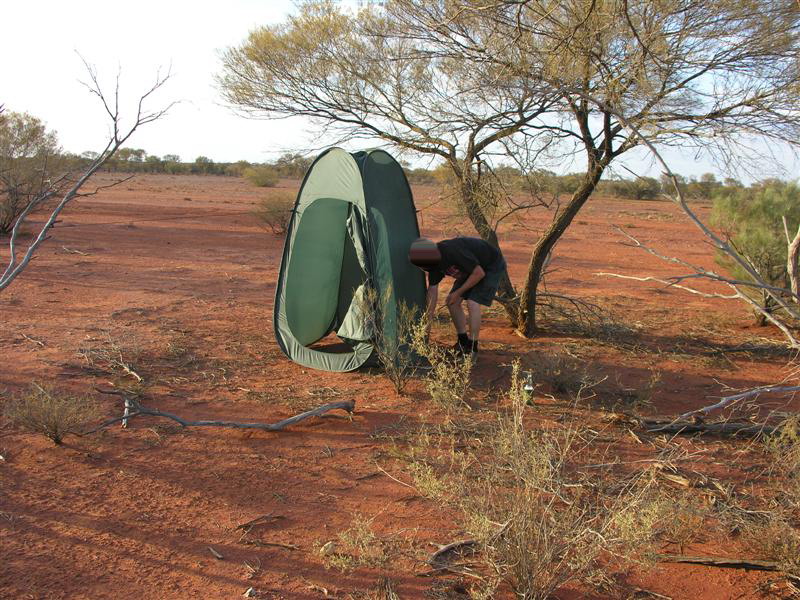
^ Wally the Cook setting up his "special tent" ... bloody city slickers
Old travel threads: Outback, Australia | Taytay, Philippines | Busuanga, Philippines | Isaan, Thailand | Phu Quoc Island, Vietnam
-
19-09-2007, 01:11 PM #60RIP

- Join Date
- Jul 2005
- Last Online
- @
- Location
- Nonthaburi
- Posts
- 4,382
do try to keep up jet...
Originally Posted by Jet Gorgon

-
19-09-2007, 01:14 PM #61RIP
- Join Date
- Jul 2005
- Last Online
- @
- Location
- Nonthaburi
- Posts
- 4,382
excellent thread WK: in the standard which we have come to expect from you...
-
19-09-2007, 01:15 PM #62Hifaluten Member
- Join Date
- Aug 2005
- Last Online
- 08-02-2019 @ 10:23 PM
- Location
- Fiji Islands
- Posts
- 3,186
-
19-09-2007, 02:41 PM #63Hifaluten Member
- Join Date
- Aug 2005
- Last Online
- 08-02-2019 @ 10:23 PM
- Location
- Fiji Islands
- Posts
- 3,186
Boulia to Camooweal Caves National Park Queensland
Anyway, back to the road
Whilst camped up at Boulia, Rog the mechanic mentioned something about some caves in the area hed like to check out. He reckoned that there was meant to be a great waterhole there that we camp by for the night. Quick check of the map and put our finger on Camooweal Caves National Park in Queensland. This joint is 1720 km northwest from Brisbane and about 190 km west of Mount Isa out in the middle of nowhere really.
We agreed to postpone our arrival in the Northern Territory a night to go and check the joint out. Along the way we crossed briefly into the Northern Territory at Tobermory Station. Check the sign into the territory whilst lovely people, the folk in the bush don't seem to spell real goood.

^ The Nature Territory ... at last
Many of the outback cattle stations have opened themselves up to tourists. They usually sell diesel, food and provide a camping ground and facilities for those who like the security of a managed camp. This station was 1.4 million acres and stretches across NT and QLD.

^ Tobermory Station in the Northern Territory good place to stop off if you like the security of a managed camp
The road up there was bloody busy with road trains transporting cattle. This one was only 3 trailers, most have 4. You just get right off the road until they all go by and the dust clears.

^ Outback road train for transporting cattle
-
19-09-2007, 02:44 PM #64Hifaluten Member
- Join Date
- Aug 2005
- Last Online
- 08-02-2019 @ 10:23 PM
- Location
- Fiji Islands
- Posts
- 3,186
Waterhole Campsite at Camooweal Caves National Park Queensland
We finally found the waterhole Rog had heard about it was magic and well worth the drive up there. You can check it out on Google Earth by clicking this blue square -

Here are a few pics of the camp that night. Being the dry season it was like all the birds in Queensland had flown to this waterhole for a drink. Bit noisy around dawn and dusk with the birds going off but being a bit of a bird lover it was great to see Australian native birds in the wild again instead of for sale at the weekend market at Chatuchack.

^ The campsite in Camooweal National Park we lucked upon

^ Corella nesting in the tree

^ The waterhole in Camooweal National Park we camped by

^ Waterhole take 2

^ Waterhole take 3 used this one earlier but its a beauty so thought Id whack it in again
-
19-09-2007, 02:46 PM #65Hifaluten Member
- Join Date
- Aug 2005
- Last Online
- 08-02-2019 @ 10:23 PM
- Location
- Fiji Islands
- Posts
- 3,186
Camooweal Caves
The Camooweal Caves is bloody big system of caves that youve gotta abseil into. As we had no abseiling gear with us we decided against trying to climb down into the suckers. Instead we spent an hour or two exploring all the sink holes. After one or two of us nearly gut struck by deadly Taipan snakes sunning themselves on the rocks we decided it was time to get our arses out of Queensland and into the Northern Territory.

^ The Camooweal Caves

^ Entrance into the Camooweal Caves bloody prime Taipan country this is
-
19-09-2007, 03:07 PM #66Thailand Expat
- Join Date
- May 2007
- Last Online
- @
- Location
- Ratsima
- Posts
- 3,717
Stunning photography.
-
19-09-2007, 03:33 PM #67Thailand Expat
- Join Date
- Mar 2007
- Last Online
- 07-12-2022 @ 03:12 PM
- Posts
- 26,746
^
Jeez Wayne,
Can you please tell " wally the cook " that i think he's a horses hoof.
Friggin shitting in a tent on a porta crapper when your in the great out back.
For fuck sake mate,
Give him a good talking to will ya, as he sounds like a tefler to me.
-
19-09-2007, 08:42 PM #68Hifaluten Member
- Join Date
- Aug 2005
- Last Online
- 08-02-2019 @ 10:23 PM
- Location
- Fiji Islands
- Posts
- 3,186
Camooweal Dunmarra
Too right ... big horses hoof ... my very words exactly
.
Thanks BH, we were covering such big distances in the early days that we didn't have much time to explore and get good photos ... would love to spend a year doing this loop instead of 30 days Originally Posted by buad hai
.
Anyway, back to the road ...
As we spent little too long dodging Taipans back at the Camooweal Caves, we found ourselves at Elliot in the Northern Territory around sunset. Elliot is about half way between Darwin and Alice Springs. Unfortunately that evening the local indigenous folks were a little wound up about something and the local shop keeper suggested it would probably be safer to stay at the Dunmarra Roadhouse -.
The trip between Camooweal and Elliot/Dunmarra was all dirt like in pic below, and it seemed the local indigenous folk were busy burning off their bush the whole way.

^ Dry dusty road between Camooweal, Queensland and Dunmarra, Northern Territory

^ Indigenous folk firing their bush between Camooweal and Dunmarra
Last edited by Wayne Kerr; 19-09-2007 at 09:44 PM.
-
19-09-2007, 08:46 PM #69Hifaluten Member
- Join Date
- Aug 2005
- Last Online
- 08-02-2019 @ 10:23 PM
- Location
- Fiji Islands
- Posts
- 3,186
Dunmarra Top Springs Roadhouse Jasper Gorge Kununurra: 1
Our mate Big Kev is an ex rally car racer and he always seems to be pushing to visit as many places as he can in a day, I suspect mainly so he can have some pushing whatever he’s driving to the limit.
So we wake up the next morning with a revised plan. He reckoned we could leave Dunmarra, then onto Top Springs Roadhouse, then Jasper Gorge in the Gregory National Park, and then Kununurra in Western Australia all in one day.
It is quite fun when he gets in one of these moods as we all know the ride will be exhilaratingly fast and dangerous – we were all up for it since the last few days had been hard going on sand and the hard roads of the Northern Territory would be a relief.

^ Top Springs Roadhouse … a few years back a truck driver went crazy here and drove his truck into the bar killing 9 people … it aint all backpacker murders out there you know.

^ Shot from the car going across Dashwood Crossing 1

^ Shot from the car going across Dashwood Crossing 2

^ Jasper Gorge in the Gregory National Park, Northern Territory – 1

^ Jasper Gorge in the Gregory National Park, Northern Territory – 2

^ Jasper Gorge in the Gregory National Park, Northern Territory – some interesting rock formations out there
Last edited by Wayne Kerr; 19-09-2007 at 09:56 PM.
-
19-09-2007, 08:51 PM #70Hifaluten Member
- Join Date
- Aug 2005
- Last Online
- 08-02-2019 @ 10:23 PM
- Location
- Fiji Islands
- Posts
- 3,186
Dunmarra Top Springs Roadhouse Jasper Gorge Kununurra: 2
The next leg of the day was from Jasper Gorge in the Northern Territory onto Kununurra in Western Australia. Now Ive done a little investigating and it seems Kununurra may be where very own MeMock calls home, and I feel like a right prick for not using my noggin and trying to catch up with the lad for a beer. The photos of this part of the world hes posted over the years are crackers. Would be great MeMock if you see this if you could post some pics that do Kununurra justice it is a bloody amazing part of the world and as far as I can tell largely man-made.
The area is irrigated by the man-made Lake Argyle, which was formed by damming the good old Ord River. Check it out on Google Earth, with all the water and rich soils it really is an oasis in the middle desert. There is lots of fruit farming, so the population there seems to be dominated by itinerant fruit pickers (lots of backpackers), people from all over the world touring with caravans, the local indigenous folk, and a minority of locals.
Heres the Google Earth link for Kununurra -.
We got there by heading up the Buchanan Highway, then onto the Victory Highway at Timber Creek. We stayed at the Kununurra Lakeside Resort, but since we were keen to keep out of towns and camp in the scrub were possible, we got out of Kununurra first the next morning headed for the Bungle Bungle Ranges.

^ Downtown Kununurra

^ A handful of the local indigenous folk enjoying a lazy day

^ Sardine can city seemed like the whole place was overrun with people from all over the towing caravans around Australia

^ Our camp site

^ Man the caravanners we met were a strange mob. Some tour around for years towing there sardine can along behind them. Would be a pretty good life but there are some nutcases amongst them. Reckon thered be a few backpacker murderers amongst them too. This bloke was travelling around with his dog and pet chook for some strange reason hed died the chooks head purple .
.
-
19-09-2007, 08:57 PM #71Thailand Expat

- Join Date
- Jun 2005
- Last Online
- @
- Location
- Baan Nok Ubon / outback Australia
- Posts
- 11,146
You better not have come to Kununurra without telling me. I;m gonna be really pissed if the next few pics are from around here
I really am loving this thread but thought I better correct a few things if I may. Dunmurra and gregory national park are in the NT not WA.News is what someone, somewhere is trying to suppress - everything else is just advertising.
-
19-09-2007, 09:01 PM #72Thailand Expat
- Join Date
- Jun 2005
- Last Online
- @
- Location
- Baan Nok Ubon / outback Australia
- Posts
- 11,146
Arrrrhhhhh you beat my post with your pics!
I seriously can't believe you didn't call in. That pic of kununurra is about 200m from my house. Those pics of the black fellas is classic (i know three of them and see them almost daily when I take my daughter for a walk every afternoon)Last edited by Wayne Kerr; 19-09-2007 at 09:57 PM.
-
19-09-2007, 09:33 PM #73
R.I.P.

- Join Date
- Jun 2005
- Last Online
- @
- Location
- Pattaya Jomtien
- Posts
- 58,763
hmmmmmm.... Originally Posted by MeMock
-
19-09-2007, 10:00 PM #74Hifaluten Member
- Join Date
- Aug 2005
- Last Online
- 08-02-2019 @ 10:23 PM
- Location
- Fiji Islands
- Posts
- 3,186
Sorry mate, somehow this post went into yours and I just cut it out. Originally Posted by MeMock
Now I feel like a right dill. Sorry for the f'up with the Gregory NP reference to WA ... not too far out though. Too many beers . Just got some more ready to put up. Hope you enjoy.
Seems a bit of a town of blow ins, including many of the indigenous folk. Are you still out in that part of the world ... we're planning the same trip for sometime during the 2008 dry season ... wouldn't mind spending a few days and hunting a few female sweedish backpackers that seemed to inundate the place.
-
19-09-2007, 10:05 PM #75Hifaluten Member
- Join Date
- Aug 2005
- Last Online
- 08-02-2019 @ 10:23 PM
- Location
- Fiji Islands
- Posts
- 3,186
Kununurra Bungle Bungle Ranges: 1
Glad to get out of the big smoke of Kununurra and on the road again, we were headed to the famous Bungle Bungle Ranges within the Purnululu National Park Purnululu National Park - Wikipedia, the free encyclopedia. The road into this park is only open in the dry season and you can see why as passing it was a little bit of a challenge in even the driest part of the year. Ill split this bit up into 3 bits. Click here to fly into the place on Google Earth
.
The first bit (this post) shows the river crossing into the place and provides some info about the Bungle Bungle Ranges. The second shows a few pics which made me realise why the local Indigenous folk believe the ancestors are in the rocks. The last bit is just a big heap of photos ... hope you enjoy.

^ River crossing into the Bungle Bungle Ranges from Kununurra

^ A little bit on the geological history of the place in plain English which is good for us simpletons

^ A bit on how the big termite mounds are formed

 Reply With Quote
Thread Information
Users Browsing this Thread
There are currently 1 users browsing this thread. (0 members and 1 guests)
